IMAGES TAKEN NEAR TO
Slade Meadow, LEAMINGTON SPA, CV31 1TL
Introduction
This page details the photographs taken nearby to Slade Meadow, CV31 1TL by members of the Geograph project.
The Geograph project started in 2005 with the aim of publishing, organising and preserving representative images for every square kilometre of Great Britain, Ireland and the Isle of Man.

There are currently over 7.5m images from over14,400 individuals and you can help contribute to the project by visiting https://www.geograph.org.uk
Image Map
Images are licensed for reuse under creativecommons.org/licenses/by-sa/2.0
Notes
- Clicking on the map will re-center to the selected point.
- The higher the marker number, the further away the image location is from the centre of the postcode.
Image Listing (19 Images Found)
Images are licensed for reuse under creativecommons.org/licenses/by-sa/2.0
Image
Details
Distance
1
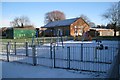
Radford Semele Community Hall
And one of several play areas. Off Lewis Road.
Image: © Robin Stott
Taken: 20 Dec 2009
0.15 miles
2
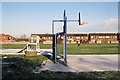
Radford Semele Recreation Ground
Looking towards the rear of Hatherell Road.
Image: © Robin Stott
Taken: 20 Dec 2009
0.15 miles
3
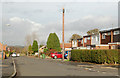
Looking north along School Lane, Radford Semele
Image: © Andy F
Taken: 12 Nov 2009
0.17 miles
5
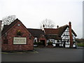
The White Lion Pub, Radford Semele, Leamington Spa
Southam Road, Leamington Spa, CV31 1TE close the Grand Union Canal
Image: © canalandriversidepubs co uk
Taken: 5 Feb 2010
0.21 miles
6
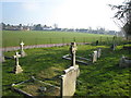
Radford Semele from St Nicholas' churchyard
7
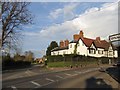
Radford Semele
The junction of the main Leamington Spa to Southam road and the road to Offchurch.
Image: © David Stowell
Taken: 14 Apr 2005
0.21 miles
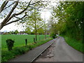
8
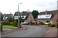
North end of Lewis Road, Radford Semele
Seen from the corner of Overtons Close.
Image: © Robin Stott
Taken: 20 Dec 2009
0.23 miles
9
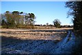
Field of stubble north-west of Valley farm
Western edge of Radford Semele in the distance.
Image: © Robin Stott
Taken: 20 Dec 2009
0.23 miles
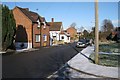
10
Church Lane Radford Semele
View from the church back up Church lane, which is a dead end leading only to the church, towards the main road the A425 which runs through the village.
Image: © Nigel Mykura
Taken: 5 May 2012
0.23 miles