IMAGES TAKEN NEAR TO
Keats Road, COVENTRY, CV2 5LA
Introduction
This page details the photographs taken nearby to Keats Road, CV2 5LA by members of the Geograph project.
The Geograph project started in 2005 with the aim of publishing, organising and preserving representative images for every square kilometre of Great Britain, Ireland and the Isle of Man.

There are currently over 7.5m images from over14,400 individuals and you can help contribute to the project by visiting https://www.geograph.org.uk
Image Map
Images are licensed for reuse under creativecommons.org/licenses/by-sa/2.0
Notes
- Clicking on the map will re-center to the selected point.
- The higher the marker number, the further away the image location is from the centre of the postcode.
Image Listing (7 Images Found)
Images are licensed for reuse under creativecommons.org/licenses/by-sa/2.0
Image
Details
Distance
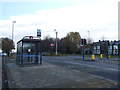
1
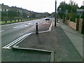
Traffic calming Hipswell Highway, Coventry
Image: © Alex McGregor
Taken: 3 Nov 2010
0.09 miles
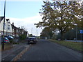
2

Coventry-The Millpool
Public House on Hipswell Highway
Image: © Ian Rob
Taken: 24 Jun 2011
0.12 miles
4
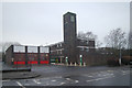
Binley fire station
Binley fire station, Hipswell Highway, Binley, Coventry, West Midlands
Image: © Kevin Hale
Taken: 25 Jan 2009
0.14 miles
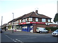
7
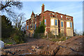
Derelict Copsewood Grange east of the Marconi site, Stoke, Coventry
The Spires, a residential development by Morris Homes, is taking shape around it. It was built in 1872, on the site of the plain, two-storey Copsewood House. It was home to the Moon family, perhaps from 1814. The 4th Baronet Moon died in 1979. An old OS map of 1925 shows the new Peel-Conner telephone works, later GEC, later Marconi, to the west of the house, and a golf course to the east running down to the River Sowe below Binley Bridge. Allard Way, first shown on a map of 1992, severed the golf course, which has transferred to land east of the river. My understanding is that Copsewood Grange became the social centre for Marconi's workers. It sits among some very fine mature specimen trees. At the time of writing, 2016, Kevin Croucher's 2005 photo and description Image is our only record of this major industrial site.
Sources: old-maps.co.uk and David McGrory: The Illustrated History of Coventry's Suburbs: Breedon Books, 2003, ISBN 1 85983 343 8
Image: © Robin Stott
Taken: 21 Nov 2015
0.25 miles