IMAGES TAKEN NEAR TO
Tapcon Way, COVENTRY, CV2 5DJ
Introduction
This page details the photographs taken nearby to Tapcon Way, CV2 5DJ by members of the Geograph project.
The Geograph project started in 2005 with the aim of publishing, organising and preserving representative images for every square kilometre of Great Britain, Ireland and the Isle of Man.

There are currently over 7.5m images from over14,400 individuals and you can help contribute to the project by visiting https://www.geograph.org.uk
Image Map
Images are licensed for reuse under creativecommons.org/licenses/by-sa/2.0
Notes
- Clicking on the map will re-center to the selected point.
- The higher the marker number, the further away the image location is from the centre of the postcode.
Image Listing (60 Images Found)
Images are licensed for reuse under creativecommons.org/licenses/by-sa/2.0
Image
Details
Distance
1
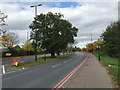
Former hedgerow oaks in the central reservation of Clifford Bridge Road, Walsgrave, Coventry
Old oaks further back on the far side of the road indicate that the far (northbound) carriageway is on the line of the original road.
Image: © Robin Stott
Taken: 22 Oct 2015
0.08 miles
2
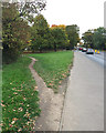
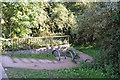
Desire line by Clifford Bridge Road, Walsgrave, Coventry
The path cuts the corner to Dorchester Way, where there is parking, a bus service and a path south away from the busy road.
Image: © Robin Stott
Taken: 23 Oct 2015
0.10 miles

4
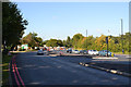
North end of Clifford Bridge Road, Walsgrave, Coventry
The traffic lights are at the turn for the University Hospital approach road just off to the right. The roadworks ahead are a remodelling of the junction with Ansty Road, A4600.
Image: © Robin Stott
Taken: 1 Oct 2015
0.12 miles
5

Flood at University Hospital Coventry
I have another photo of the Air Ambulance on exactly this spot in square SP3780. Here is a pile of rubble where that air ambulance stood, entirely surrounded by the river water that is flowing onto the car park at the back of the Clinical Sciences Research Institute, University Hospital Coventry.
Image: © Helga Perry
Taken: 15 Jun 2007
0.12 miles
6
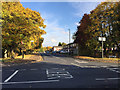
West end of Dorchester Way seen across Clifford Bridge Road, Walsgrave, Coventry
Autumn colour in trees in 2015 was memorable, seen well in many Norway Maples, Acer platanoides, in this area.
Image: © Robin Stott
Taken: 28 Oct 2015
0.12 miles
7
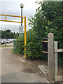
Access to the Sowe Valley Footpath from the University Hospital approach road, Coventry
It's fairly well used and is a pleasanter walk to some parking in Dorchester Way than walking by Clifford Bridge Road. The hoops seem to deter bikes and motorbikes.
Image: © Robin Stott
Taken: 1 Oct 2015
0.13 miles
8
Sowe Valley Footpath heads north from University Hospital approach, east Coventry
The path runs through a staff car park to Ansty Road. It's parallel to the river but there's no sight of it through dense vegetation.
Image: © Robin Stott
Taken: 13 Jun 2016
0.13 miles
9

Big old lime tree, Caludon Castle Park, Wyken, Coventry
Near the Farren Road gates; upwards of 30 metres high. The tree, with others along the drive, is probably Common Lime (Tilia x europea) but might be Small-leaved Lime, given the age of the site. Early autumn is not the best time of year for identifying trees.
Image: © Robin Stott
Taken: 1 Oct 2015
0.13 miles
10

Gates to Caludon Castle Park, Farren Road, Wyken, Coventry
Image: © Robin Stott
Taken: 1 Oct 2015
0.14 miles