
IMAGES TAKEN NEAR TO
Dennis Road, COVENTRY, CV2 3HP
Introduction
This page details the photographs taken nearby to Dennis Road, CV2 3HP by members of the Geograph project.
The Geograph project started in 2005 with the aim of publishing, organising and preserving representative images for every square kilometre of Great Britain, Ireland and the Isle of Man.

There are currently over 7.5m images from over14,400 individuals and you can help contribute to the project by visiting https://www.geograph.org.uk
Image Map
Images are licensed for reuse under creativecommons.org/licenses/by-sa/2.0
Notes
- Clicking on the map will re-center to the selected point.
- The higher the marker number, the further away the image location is from the centre of the postcode.
Image Listing (4 Images Found)
Images are licensed for reuse under creativecommons.org/licenses/by-sa/2.0
Image
Details
Distance
1
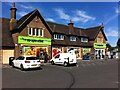
The Grange, now a Co-op store, Stoke, Coventry
The Grange public house on Alfall Road opened in 1937, according to the Coventry's Pub History site https://pubhistory.historiccoventry.co.uk/main/pub.php?pg=grange . It took its name from Wyken Grange Farm, on which the houses in this area were built. The pub closed in 2013 and reopened as a convenience store of the Heart of England Co-operative Society in 2016. Note the outdoor automatic mini-laundrette facing onto the car park just beyond the store entrance.
Image: © A J Paxton
Taken: 7 Aug 2022
0.13 miles
2
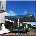
Disused garage, corner of Dennis Road and Alfall Road, Coventry
The former Grange pub, now a Co-op store, can be seen across Dennis Road.
Image: © A J Paxton
Taken: 7 Aug 2022
0.14 miles
3
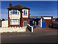
Luxury Bakery, Alfall Road
The uncial, 'Celtic' lettering of the sign suggests an Irish bakery, but it is stronger on samosas than soda bread, which reflects changes in the local population of Stoke, Coventry, over the years.
Image: © A J Paxton
Taken: 17 Sep 2022
0.21 miles
4
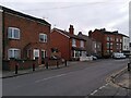
North Street, Stoke, Coventry
North Street forms part of Upper Stoke, a block of streets to the east of Barras Heath that seems to have been built up piecemeal in the 19th century with a great variety of house types. The row of six three-storey houses to the right are unmistakeably ribbon-weavers' houses with their high top-shops on the topmost floor for the tall jacquard looms. The outlines of the large windows, now partly filled in with bricks of a different colour and texture, can clearly be seen, except on the pair of houses that have been rendered.
The pair of houses on the left has the red and yellow chequerboard brickwork that is very common in parts of Warwickshire.
Image: © A J Paxton
Taken: 12 Feb 2023
0.22 miles