IMAGES TAKEN NEAR TO
London Road, RUGBY, CV23 9HN
Introduction
This page details the photographs taken nearby to London Road, CV23 9HN by members of the Geograph project.
The Geograph project started in 2005 with the aim of publishing, organising and preserving representative images for every square kilometre of Great Britain, Ireland and the Isle of Man.

There are currently over 7.5m images from over14,400 individuals and you can help contribute to the project by visiting https://www.geograph.org.uk
Image Map
Images are licensed for reuse under creativecommons.org/licenses/by-sa/2.0
Notes
- Clicking on the map will re-center to the selected point.
- The higher the marker number, the further away the image location is from the centre of the postcode.
Image Listing (11 Images Found)
Images are licensed for reuse under creativecommons.org/licenses/by-sa/2.0
Image
Details
Distance
1
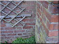
Bench mark on old cottage
This bench mark (bottom centre of photo) was established in 1848 during the First primary levelling of England & Wales, and was levelled with a height of 337.0300 feet [102.7267 metres] above mean sea level (Liverpool datum). It was included on the Birmingham to London levelling line. The surveyor's description was "No. 75. Mark on house in Knightlow-hill Village, at N.E. side of road ; 0.82 ft. above centre of road" (p221). The 1887 map shows this mark on the south-west face, south angle of a cottage, which still stands, set back from the road. The mark is on front of the house (next to outbuilding), and now filled with mortar.
Image: © Shantavira
Taken: 21 Mar 2015
0.09 miles
2
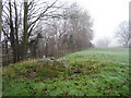
Knightlow Cross
This shows the surviving base of the ancient Knightlow Cross on its mound. It is adjacent to the modern A45 running east/west on the other side of the tall hedge on the left, close to where the old north/south track Freeboard Lane crosses it. About 3/4 mile to the east is the roman north/south Fosse Way.
More about it here http://www.ourwarwickshire.org.uk/content/topics/traditions-and-customs/wroth-silver-ceremony-knightlow-cross
Image: © Robert Caldicott
Taken: 9 Dec 2014
0.13 miles
3
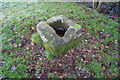
Knightlow Cross
This is the base remnant of the ancient wayside Knightlow Cross at the top of Knightlow Hill beside the A45 (visible through the trees). The hole is the socket where the upright stem of the cross would have been placed. There is more about it here http://www.ourwarwickshire.org.uk/content/topics/traditions-and-customs/wroth-silver-ceremony-knightlow-cross
Image: © Robert Caldicott
Taken: 9 Dec 2014
0.13 miles
4
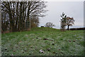
View from Knightlow Hill
Looking NW across the fields at the top of the hill, with the spires and tower blocks of Coventry in the distance.
Image: © David Stowell
Taken: 15 Aug 2005
0.14 miles
5
Knightlow Hill - so near and yet so far!
The small hamlet at the top of Knightlow Hill on the busy A45 dual carriageway. The view is seen from Freeboard lane, however to reach the other side by road is a 3 mile round trip to the nearest roundabout by road. The lack of pedestrian crossing facilities also makes the trip on foot no easier.
Image: © David Stowell
Taken: 15 Aug 2005
0.14 miles
6
The Wroth Stone
The Wroth Stone lies atop a low mound, close to the A45, and is found just off the public footpath to the left of the properties opposite Freeboard Lane. For more information on this ancient site I suggest looking at www.themodernantiquarian.com/site/2452
Image: © Ian Coldicott
Taken: 22 Dec 2006
0.20 miles
7
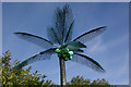
Plastic palm tree
This is one of a pair of plastic palm trees that stand by the entrance to the car park at the former Goji Chinese restaurant - although they may date back to the days when the building was 'Crazy Daisy's' - a night club. Presumably they were intended to give a hint of the orient, or to convince clubbers they were in Ibiza. Either way they are unbelievably tacky, and look distinctly odd standing next to a derelict building - for context see Image .
Image: © Stephen McKay
Taken: 5 Apr 2009
0.20 miles
8
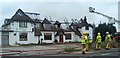
Fire damaged derelict restaurant
The former nightclub and Chinese restaurant on the A45 near Stretton-on-Dunsmore, Warwickshire being hosed down after a fire.
Image: © Richard Lawson
Taken: 15 May 2011
0.21 miles
9
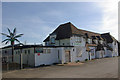
Former Goji Restaurant, Stretton on Dunsmore
This building has had various uses over the years - for several years it was an out-of-town night club called 'Crazy Daisy's'. Its most recent incarnation was as a Chinese restaurant - indeed it is listed as the headquarters of the Goji chain, which appears to have folded. This is one of several failed enterprises along this stretch of the A45, giving the road a rather war-torn appearance; here is another example: Image .
Image: © Stephen McKay
Taken: 5 Apr 2009
0.21 miles
10
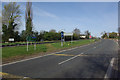
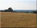
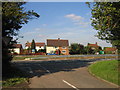
A45 at Stretton on Dunsmore
The Wolston - Stretton on Dunsmore road crosses the A45 here, but motor traffic has to divert via the Fosse Way roundabout.
Image: © Stephen McKay
Taken: 5 Apr 2009
0.23 miles