IMAGES TAKEN NEAR TO
Ophelia Crescent, RUGBY, CV22 7UU
Introduction
This page details the photographs taken nearby to Ophelia Crescent, CV22 7UU by members of the Geograph project.
The Geograph project started in 2005 with the aim of publishing, organising and preserving representative images for every square kilometre of Great Britain, Ireland and the Isle of Man.

There are currently over 7.5m images from over14,400 individuals and you can help contribute to the project by visiting https://www.geograph.org.uk
Image Map
Images are licensed for reuse under creativecommons.org/licenses/by-sa/2.0
Notes
- Clicking on the map will re-center to the selected point.
- The higher the marker number, the further away the image location is from the centre of the postcode.
Image Listing (18 Images Found)
Images are licensed for reuse under creativecommons.org/licenses/by-sa/2.0
Image
Details
Distance
1
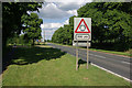
A4071 at Cawston
The roundabout 200 yards ahead is a relatively new feature, built to give access to the Cawston Grange Estate.
Image: © Stephen McKay
Taken: 14 Jun 2009
0.11 miles
2

Cawston
The old part of Cawston, seen from the footpath to Lawford Heath.
Image: © Ian Rob
Taken: 6 Jun 2006
0.13 miles
3
Cawston Grange Estate
The main entrance to the estate from the A4071.
Image: © Ian Rob
Taken: 30 Oct 2007
0.14 miles
4

The old part of Cawston
The original hamlet was a ribbon of houses on the north side of the A4071. The population has expanded with the large Cawston Grange Estate development which now almost links it to Bilton.
Image: © Ian Rob
Taken: 29 Dec 2007
0.17 miles
5
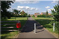
Bridleway through Cawston Grange Estate
The estate has covered the land once occupied by Cawston Grange Farm but the bridleway that once crossed this land can still be followed - more or less - now a tarmaced path.
Image: © Stephen McKay
Taken: 14 Jun 2009
0.18 miles
6
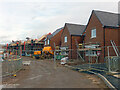
New houses at Cawston
Houses in various stages of construction on the Linden Homes' 'The Spinneys' development.
Image: © Stephen McKay
Taken: 21 Jan 2021
0.18 miles
7
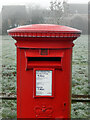
Postbox - Cawston Grange Estate
This facility is located on Calvestone Road. Although taken mid-afternoon, frost is still very much in evidence and the cobwebs on the postbox are covered in rime.
Image: © Stephen McKay
Taken: 7 Jan 2021
0.19 miles
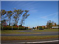
8
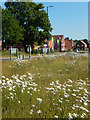
Elborow Way, Cawston
Looking across the Coventry Road roundabout to the new 'Tilia Park' housing development.
Image: © Stephen McKay
Taken: 28 May 2020
0.20 miles
9
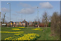
Daffodils at Cawston
Motorists approaching Rugby via the A4071 are treated to a splendid display of daffodils in March as they negotiate the roundabout that gives access to the new Cawston Grange Estate.
Image: © Stephen McKay
Taken: 22 Mar 2009
0.20 miles
10

Elborow Way, Cawston
This is part of the Ashberry Homes' Tilia Park development. The Elborow name commemorates a school in Rugby, originally set up to provide an education for poor children in the borough, that closed in 1960. Other streets on the estate are named after some of the school's headmasters and headmistresses.
Image: © Stephen McKay
Taken: 28 May 2020
0.21 miles