IMAGES TAKEN NEAR TO
Mill Farm Close, RUGBY, CV22 6QL
Introduction
This page details the photographs taken nearby to Mill Farm Close, CV22 6QL by members of the Geograph project.
The Geograph project started in 2005 with the aim of publishing, organising and preserving representative images for every square kilometre of Great Britain, Ireland and the Isle of Man.

There are currently over 7.5m images from over14,400 individuals and you can help contribute to the project by visiting https://www.geograph.org.uk
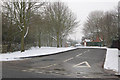
Image Map
Images are licensed for reuse under creativecommons.org/licenses/by-sa/2.0
Notes
- Clicking on the map will re-center to the selected point.
- The higher the marker number, the further away the image location is from the centre of the postcode.
Image Listing (109 Images Found)
Images are licensed for reuse under creativecommons.org/licenses/by-sa/2.0
Image
Details
Distance
1
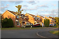
Wise Farm Close, Dunchurch
Evening sun on the junction of Wise Farm Close and Sandford Way, Dunchurch.
Image: © Andy F
Taken: 22 May 2009
0.02 miles
2
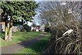
Path to Mill Farm Close, Dunchurch
The path leads off Sandford Way making a convenient short cut across the estate. The house in the picture is typical of those on Sandford Way and associated streets.
Image: © Stephen McKay
Taken: 22 Mar 2021
0.03 miles
3
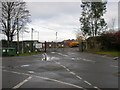
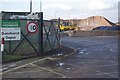
Dunchurch-Southam Road
Warwickshire Highways Depot off Southam Road.
Image: © Ian Rob
Taken: 28 Nov 2007
0.06 miles
4
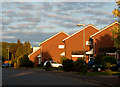
Sandford Way, Dunchurch
Evening sun on houses in Sandford Way, Dunchurch.
Image: © Andy F
Taken: 22 May 2009
0.06 miles
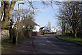
5

Sandford Way, Dunchurch
Suburban-style housing off Southam Road.
Image: © Stephen McKay
Taken: 30 Jan 2012
0.07 miles
6
Junction of Sandford Way and A426, Dunchurch
Image: © Andy F
Taken: 13 Jan 2010
0.07 miles
7
Sandford Way, Dunchurch
Sandford Way forms a semi-circle off Southam Road to the south of Dunchurch village centre. It is the spine of a small estate of detached houses.
Image: © Stephen McKay
Taken: 22 Mar 2021
0.08 miles
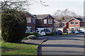
8
Dew Close, Dunchurch
Well-spaced detached houses on Dew Close, seen from Sandford wAy.
Image: © Stephen McKay
Taken: 22 Mar 2021
0.08 miles
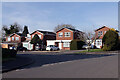
9
Sandford Way, Dunchurch
Looking towards Southam Road. Note the unusual house by the junction.
Image: © Stephen McKay
Taken: 22 Mar 2021
0.09 miles
10
Dunchurch Depot
Rock salt is piled high ready for spreading on the county's roads and, although not needed much so far this winter, if the forecasts are correct the gritters will be required for the next few nights at least. The speed restriction sign seems curiously makeshift for what is, after all, a Highways Department depot.
Image: © Stephen McKay
Taken: 30 Jan 2012
0.09 miles