IMAGES TAKEN NEAR TO
Clifton Road, RUGBY, CV21 3AG
Introduction
This page details the photographs taken nearby to Clifton Road, CV21 3AG by members of the Geograph project.
The Geograph project started in 2005 with the aim of publishing, organising and preserving representative images for every square kilometre of Great Britain, Ireland and the Isle of Man.

There are currently over 7.5m images from over14,400 individuals and you can help contribute to the project by visiting https://www.geograph.org.uk
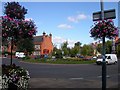
Image Map
Images are licensed for reuse under creativecommons.org/licenses/by-sa/2.0
Notes
- Clicking on the map will re-center to the selected point.
- The higher the marker number, the further away the image location is from the centre of the postcode.
Image Listing (215 Images Found)
Images are licensed for reuse under creativecommons.org/licenses/by-sa/2.0
Image
Details
Distance
1
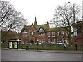
Rugby - Clifton Rd
Lawrence Sheriff Grammar School for Boys
Image: © Ian Rob
Taken: 25 Jan 2006
0.02 miles
2
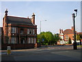
Rugby-Clifton Road
Showing the top of Murray Road and one of Rugby's many CCTV cameras.
Image: © Ian Rob
Taken: 11 May 2008
0.02 miles
3

Rugby-Clifton Road
Looking across the traffic island from the top of Murray Road,
Image: © Ian Rob
Taken: 22 Aug 2010
0.02 miles
4
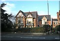
Rugby Care Centre
A private care home in Clifton Road.
Image: © Ian Rob
Taken: 17 Jan 2011
0.02 miles
5
Rugby-Clifton Road
Looking across to Lawrence Sheriff School from the corner of Murray Road.
Image: © Ian Rob
Taken: 14 Jun 2008
0.04 miles
6
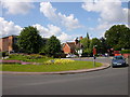
Rugby-Clifton Road
This busy Traffic Island has five major roads radiating from it. Looking from Lower Hillmorton Road across to Murray Road.
Image: © Ian Rob
Taken: 7 Sep 2006
0.04 miles
7
Rugby - Whitehall Road
Near the junction with Clifton Road.The large houses on the left are generally Doctors and Dentists.
Image: © Ian Rob
Taken: 14 Nov 2006
0.04 miles
8
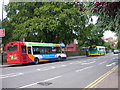
Rugby-Clifton Road
Buses in front of Lawrence Sheriff School. There are several Bus Stops on both sides of the road in this area.The Stagecoach Bus in the foreground is on the Brownsover to Cawston route. The green Countylinks bus is on route from Rugby to Leamington via Stockton and Southam.
Image: © Ian Rob
Taken: 14 Jun 2008
0.05 miles
9
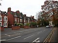
Whitehall Road, Rugby
Whitehall Road is a short street that connects Hillmorton Road with Clifton Road at the eastern end of Rugby town centre. The western side of the road abuts Lawrence Sheriff School and its staff car park; on the eastern side is a series of large villas mainly used by professional businesses - solicitors and the like.
Image: © Stephen McKay
Taken: 17 Jan 2023
0.05 miles
10
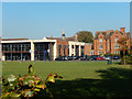
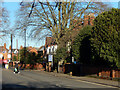
Lawrence Sheriff School, Rugby
Lawrence Sheriff School is a boys' selective grammar school named after the founder of nearby Rugby School. It originally opened in 1878 as a lower school from which boys could gain scholarships to Rugby School. Today it has academy status and an enviable academic record - in 2008, 2010 and 2011 the school came first in national performance tables based on examination results. The modern block at the rear seen in this view is the Learning Resources Centre which houses classrooms for maths and computing as well as a library.
Image: © Stephen McKay
Taken: 10 Oct 2018
0.05 miles