IMAGES TAKEN NEAR TO
Grendon Drive, RUGBY, CV21 1UA
Introduction
This page details the photographs taken nearby to Grendon Drive, CV21 1UA by members of the Geograph project.
The Geograph project started in 2005 with the aim of publishing, organising and preserving representative images for every square kilometre of Great Britain, Ireland and the Isle of Man.

There are currently over 7.5m images from over14,400 individuals and you can help contribute to the project by visiting https://www.geograph.org.uk
Image Map (Loading...)


Getting Data...Please wait
Leaflet Map data © OpenStreetMap
Images are licensed for reuse under creativecommons.org/licenses/by-sa/2.0
Notes
- Clicking on the map will re-center to the selected point.
- The higher the marker number, the further away the image location is from the centre of the postcode.
Image Listing (7 Images Found)
Images are licensed for reuse under creativecommons.org/licenses/by-sa/2.0
Image
Details
Distance
1
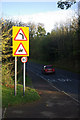
Newton Manor Lane
A car slows for the bend just east of the Crowthorns junction, passing the site of the Great Central railway bridge.
Image: © Stephen McKay
Taken: 26 Oct 2008
0.08 miles
2
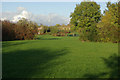
Brooklime Drive Open Space, Brownsover
Open area on the north eastern edge of Brownsover, seen here from Newton Manor Lane.
Image: © Stephen McKay
Taken: 26 Oct 2008
0.09 miles
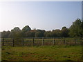
3

Brownsover -Great Central Walk
The Trackbed of the Great Central Railway. Now a leisure route through the estate.
Image: © Ian Rob
Taken: 30 Apr 2008
0.10 miles
4

Brownsover-Great Central Walk
Staveley Way crosses the course of the old railway.
Image: © Ian Rob
Taken: 15 Aug 2011
0.11 miles
5
Brownsover - Newton lane
Disused Great Central Railway north of Newton Lane, close to Newton Manor.
Image: © Ian Rob
Taken: 15 Oct 2005
0.11 miles
6
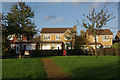
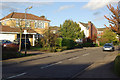
Gentian Way, Brownsover
These houses on Gentian Way look onto the Brooklime Drive Open Space maintained by Rugby Borough Council.
Image: © Stephen McKay
Taken: 26 Oct 2008
0.22 miles
7
Gentian Way, Brownsover
Leafy suburban cul-de-sac at the north eastern tip of Brownsover, seen here from the junction with Campion Way.
Image: © Stephen McKay
Taken: 26 Oct 2008
0.24 miles