IMAGES TAKEN NEAR TO
Finmere, RUGBY, CV21 1RT
Introduction
This page details the photographs taken nearby to Finmere, CV21 1RT by members of the Geograph project.
The Geograph project started in 2005 with the aim of publishing, organising and preserving representative images for every square kilometre of Great Britain, Ireland and the Isle of Man.

There are currently over 7.5m images from over14,400 individuals and you can help contribute to the project by visiting https://www.geograph.org.uk
Image Map (Loading...)


Getting Data...Please wait
Leaflet Map data © OpenStreetMap
Images are licensed for reuse under creativecommons.org/licenses/by-sa/2.0
Notes
- Clicking on the map will re-center to the selected point.
- The higher the marker number, the further away the image location is from the centre of the postcode.
Image Listing (14 Images Found)
Images are licensed for reuse under creativecommons.org/licenses/by-sa/2.0
Image
Details
Distance
1

Brownsover-Great Central Walk
Footpath through the estate on the dismantled railway.
Image: © Ian Rob
Taken: 15 Aug 2011
0.05 miles
2
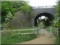
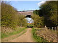
Brownsover Footpath
The footpath from Clifton passes under the dismantled Great Central Railway.
Image: © Ian Rob
Taken: 5 May 2011
0.17 miles
3
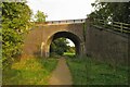
Disused railway bridge over the footpath
Image: © Philip Jeffrey
Taken: 8 Oct 2023
0.17 miles
4
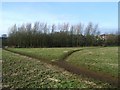
Intersection of field trails, near Brownsover
South of Brownsover, alongside River Avon, a trail splits in two. First, to right, is track towards south of Brownsover, via a right of way and footpaths under the former Great Central Railway bridge (seen on right). The other, to left, terminates near to River Avon's bridge under former railway.
Image: © Michael Westley
Taken: 21 Jan 2010
0.19 miles
5
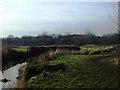
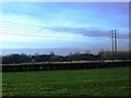
Avon riverbank and former GCR
Footpath alongside River Avon, from Clifton, in direction of Brownsover, route of former Great Central Railway in distance.
Image: © Michael Westley
Taken: 21 Jan 2010
0.20 miles
6
Rugby- Brownsover
The Footpath to Clifton-On-Dunsmore passes under the dismantled Great Central Railway.
Image: © Ian Rob
Taken: 8 Apr 2007
0.21 miles
7
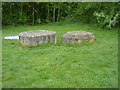
Brownsover Farmland
Raised drain covers between the railway embankment and the river.
Image: © Ian Rob
Taken: 5 May 2011
0.21 miles
8

Brownsover -Great Central Walk
The Trackbed of the Great Central Railway. Now a leisure route through the estate.
Image: © Ian Rob
Taken: 30 Apr 2008
0.23 miles
9

Brownsover-Great Central Walk
Staveley Way crosses the course of the old railway.
Image: © Ian Rob
Taken: 15 Aug 2011
0.23 miles
10
Great Central Railway route, near Brownsover
Viewed from field footpath from Mill Lane, Clifton, showing clearly the two bridge arches in the distance.
Image: © Michael Westley
Taken: 21 Jan 2010
0.23 miles