IMAGES TAKEN NEAR TO
Conisbrough Keep, COVENTRY, CV1 5PP
Introduction
This page details the photographs taken nearby to Conisbrough Keep, CV1 5PP by members of the Geograph project.
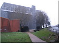
The Geograph project started in 2005 with the aim of publishing, organising and preserving representative images for every square kilometre of Great Britain, Ireland and the Isle of Man.

There are currently over 7.5m images from over14,400 individuals and you can help contribute to the project by visiting https://www.geograph.org.uk
Image Map
Images are licensed for reuse under creativecommons.org/licenses/by-sa/2.0
Notes
- Clicking on the map will re-center to the selected point.
- The higher the marker number, the further away the image location is from the centre of the postcode.
Image Listing (651 Images Found)
Images are licensed for reuse under creativecommons.org/licenses/by-sa/2.0
Image
Details
Distance
1
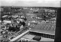
View north-east from Priory Hall, 1967
Looking over the rooftops towards Wyken.
Fairfax Street and Cox Street in the foreground.
Demolition is taking place on Cox Street to make way for the Ring Road.
The roof of another factory building behind has also been removed - I think that this was the old Francis Barnett factory.
Image: © Richard Warren
Taken: 16 Aug 1967
0.05 miles
2
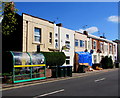
Lower Ford Street houses, wheelie bins and bus shelter, Coventry
SE of the Alma Street junction.
Image: © Jaggery
Taken: 18 Apr 2015
0.05 miles
3
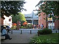
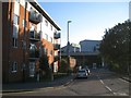
Looking across Lower Ford Street to Conisbrough Keep, Coventry
Conisbrough Keep appears to be a gated private road serving several blocks of student accommodation; another block is on the right. The viewpoint is a welcome scrap of open space at the acute corner of Lower Ford Street and Alma Street.
Image: © Robin Stott
Taken: 22 Sep 2013
0.05 miles
4
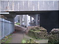
City wall and Ringway Whitefriars
A remnant of city wall[1], with ashlar facing and rubble infill visible. Behind are the slip road and supports for the ring road junction.
Image: © E Gammie
Taken: 31 Dec 2008
0.06 miles
5
Severed road leading to Lower Ford Street car park, Coventry
The building on the left is Bodiam Hall, student accommodation for Coventry University. The low brick structure beyond it is an electrical substation, judging by aerial photos. Ringway Whitefriars sails by with Coventry Sports Centre beyond.
Image: © Robin Stott
Taken: 22 Sep 2013
0.06 miles
6
City wall under Ringway Whitefriars
The remnant of wall[1] alongside the footpath leading to the bottom of Gosford Street, where Gosford Gate once stood. In the background the slip road to Sky Blue Way roundabout.
Image: © E Gammie
Taken: 31 Dec 2008
0.07 miles
7
City wall and slip road
Remains of the city wall[1] alongside the footpath leading to the bottom of Gosford Street, where Gosford Gate once stood. The slip road joins the ring road from Sky Blue Way roundabout.
Image: © E Gammie
Taken: 31 Dec 2008
0.07 miles
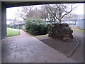
8
Green space by Cox Street
A small green space on the site of the former Cox Street Working Men's Club. The side panels of the ring road flyover have been renovated with a patterned effect that breaks up the outline.
Image: © E Gammie
Taken: 23 Jun 2018
0.07 miles
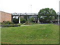
9
Sports centre, Cox Street
Looking somewhat like a grazing elephant, the sports centre, opened in 1977, straddles Cox Street and is attached to the swimming pool building. A slip road to the ring road rises to the right.
Image: © E Gammie
Taken: 31 Dec 2008
0.07 miles
10
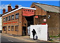
Seymour Paper & Packaging, Coventry
Viewed across Lower Ford Street.
Image: © Jaggery
Taken: 18 Apr 2015
0.07 miles