IMAGES TAKEN NEAR TO
Bird Street, COVENTRY, CV1 5FX
Introduction
This page details the photographs taken nearby to Bird Street, CV1 5FX by members of the Geograph project.
The Geograph project started in 2005 with the aim of publishing, organising and preserving representative images for every square kilometre of Great Britain, Ireland and the Isle of Man.

There are currently over 7.5m images from over14,400 individuals and you can help contribute to the project by visiting https://www.geograph.org.uk
Image Map
Images are licensed for reuse under creativecommons.org/licenses/by-sa/2.0
Notes
- Clicking on the map will re-center to the selected point.
- The higher the marker number, the further away the image location is from the centre of the postcode.
Image Listing (694 Images Found)
Images are licensed for reuse under creativecommons.org/licenses/by-sa/2.0
Image
Details
Distance
1
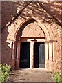
Doorway at the Swanswell Centre
The building is a former church.
Image: © Keith Williams
Taken: 12 May 2015
0.03 miles
2
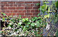
Benchmark on disused hospital on NW side of Stoney Stanton Road
Only the datum cut of the Ordnance Survey cut mark bench mark (which is described on the Bench Mark Database at www.bench-marks.org.uk/bm113715 ) is visible above the cut down vegetation
Image: © Luke Shaw
Taken: 17 Aug 2018
0.03 miles
3
Disused hospital, Stoney Stanton Road
There is an OS benchmark Image on the near corner of the building where the metal fence abuts
Image: © Luke Shaw
Taken: 17 Aug 2018
0.03 miles
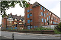
4
Old Coventry and Warwick Hospital
One of the old hospital buildings that is now boarded up. Most of the hospital admissions for Coventry are now taken at the University Hospital at Walsgrave. This site on Stoney Stanton Road will probably be redeveloped.
Edmund Bird informs me that this building was listed Grade II by English Heritage by virtue of its special historic and architectural interest in 1998 (together with the old outpatients block on the corner of Swanswell and Stony Stanton Road) so both are protected from demolition. Hopefully a new use can bring them to life once again soon.
Image: © Nigel Mykura
Taken: 13 Dec 2010
0.04 miles
5
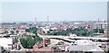
Swanswell and Foleshill
In 1975, from the tower of St Michael's cathedral church. Foreground left: The white building is the Art Deco style Coventry Theatre (The Hippodrome) demolished in 2002 and replaced by an extension to the Coventry Transport Museum. The red-brick building with a tower is the old fire station, now restaurants. The trees within the inner ring road are in Lady Herbert's Garden, within which is a stretch of the old town wall (built 14th-16th centuries) at either end of which are the only two surviving town gates: Cook Street Gate at the far end and Swanswell Gate this end. Just beyond the ring road is Swanswell pool and park, next to Coventry and Warwickshire Hospital. Beyond is Foleshill and on the centre horizon the gas holders of Foleshill gas works, the last of which was demolished in 2002.
The central tall industrial chimney is the 365ft (111m) high Courtaulds chimney, built 1924, demolished around 1987. To its left is the smaller 164ft (50m) chimney, also Courtaulds, demolished in 2010.
This view is taken from the same position and in the same direction as the BBC Domesday reloaded 1986 photograph.
A 2007 view in this direction: http://www.geograph.org.uk/photo/560234
Image: © E Gammie
Taken: 11 Jun 1975
0.05 miles
6
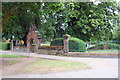
Entrance to Swanswell Park from Bird Street
There is an OS benchmark Image on the stone wall left of the wall pier in the middle of the image
Image: © Luke Shaw
Taken: 17 Aug 2018
0.05 miles
7
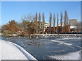
Swanswell Pool
The fountains are still flowing, despite the sub-zero temperatures. A variety of bird-life is perched on the ice - mainly geese, gulls, ducks, a few swans and a coot or two.
Image: © E Gammie
Taken: 19 Dec 2010
0.05 miles
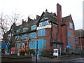
8
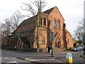
Coventry-Saint Mark's Church
On Stoney Stanton Road. It dates from 1868 and closed in 1972. More recently it became part of Coventry and Warwickshire Hospital
Image: © Ian Rob
Taken: 7 Dec 2007
0.05 miles
9
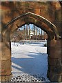
Gateway to Swanswell Park
A sandstone arch frames one of the entrances into the small park that surrounds Swanswell Pool.
Image: © E Gammie
Taken: 19 Dec 2010
0.05 miles
10
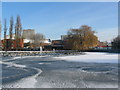
Swanswell Pool
Ice, snow and bird-life on Swanswell Pool. The pool is long-established and shown on John Speed's 1610 map of Coventry. It was later incorporated into a small recreational park.
Image: © E Gammie
Taken: 19 Dec 2010
0.06 miles