Swanswell and Foleshill
Introduction
The photograph on this page of Swanswell and Foleshill by E Gammie as part of the Geograph project.
The Geograph project started in 2005 with the aim of publishing, organising and preserving representative images for every square kilometre of Great Britain, Ireland and the Isle of Man.

There are currently over 7.5m images from over 14,400 individuals and you can help contribute to the project by visiting https://www.geograph.org.uk
Swanswell and Foleshill
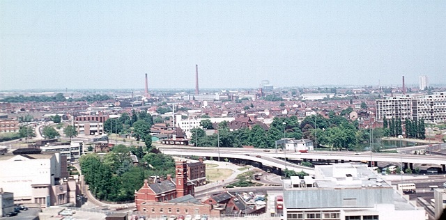
Image: © E Gammie Taken: 11 Jun 1975
In 1975, from the tower of St Michael's cathedral church. Foreground left: The white building is the Art Deco style Coventry Theatre (The Hippodrome) demolished in 2002 and replaced by an extension to the Coventry Transport Museum. The red-brick building with a tower is the old fire station, now restaurants. The trees within the inner ring road are in Lady Herbert's Garden, within which is a stretch of the old town wall (built 14th-16th centuries) at either end of which are the only two surviving town gates: Cook Street Gate at the far end and Swanswell Gate this end. Just beyond the ring road is Swanswell pool and park, next to Coventry and Warwickshire Hospital. Beyond is Foleshill and on the centre horizon the gas holders of Foleshill gas works, the last of which was demolished in 2002. The central tall industrial chimney is the 365ft (111m) high Courtaulds chimney, built 1924, demolished around 1987. To its left is the smaller 164ft (50m) chimney, also Courtaulds, demolished in 2010. This view is taken from the same position and in the same direction as the BBC Domesday reloaded 1986 photograph. A 2007 view in this direction: http://www.geograph.org.uk/photo/560234
Images are licensed for reuse under creativecommons.org/licenses/by-sa/2.0
Image Location
Latitude
52.412745
Longitude
-1.507595