IMAGES TAKEN NEAR TO
Somerset Road, COVENTRY, CV1 4EG
Introduction
This page details the photographs taken nearby to Somerset Road, CV1 4EG by members of the Geograph project.
The Geograph project started in 2005 with the aim of publishing, organising and preserving representative images for every square kilometre of Great Britain, Ireland and the Isle of Man.

There are currently over 7.5m images from over14,400 individuals and you can help contribute to the project by visiting https://www.geograph.org.uk
Image Map
Images are licensed for reuse under creativecommons.org/licenses/by-sa/2.0
Notes
- Clicking on the map will re-center to the selected point.
- The higher the marker number, the further away the image location is from the centre of the postcode.
Image Listing (130 Images Found)
Images are licensed for reuse under creativecommons.org/licenses/by-sa/2.0
Image
Details
Distance
2
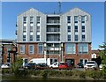
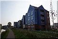
Boiler House, Electric Wharf
Residential units made to look like industrial buildings, a reversal of the normal trend. The lower part of the building includes commercial units, making use of some original structure, the upper stories comprise residential units, including student accommodation.
Image: © Alan Murray-Rust
Taken: 23 Sep 2021
0.10 miles
3

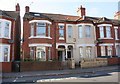
Widdrington Court private car park on Widdrington Road
This site used to house a garage and small petrol station. You can see where the pavement has been lowered for cars to enter and leave the forecourt of the former petrol station. The houses in the background are in Somerset Road.
Image: © starkderrick
Taken: 10 Oct 2011
0.10 miles
4
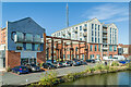
Electric Wharf
Part of Electric Wharf, the name given to the early 2000s commercial and residential redevelopment of the 1895 Sandy Lane Power Station, situated alongside the Coventry Canal.
Image: © Ian Capper
Taken: 23 Sep 2021
0.10 miles
5

Cable Yard
Part of Electric Wharf, the name given to the early 2000s commercial and residential redevelopment of the 1895 Sandy Lane Power Station, situated alongside the Coventry Canal.
Image: © Ian Capper
Taken: 23 Sep 2021
0.10 miles
6

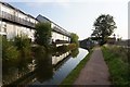
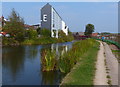
Coventry Canal
Looking along the Coventry Canal. On the left are two parts of Electric Wharf, the name given to the early 2000s commercial and residential redevelopment of the 1895 Sandy Lane Power Station, with early 20th Century houses in Aldbourne Road between them. On the right are Progress House, Waterways House and Potters House in Quayside Court, completed in 2016/7.
Image: © Ian Capper
Taken: 23 Sep 2021
0.10 miles
7
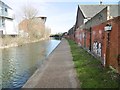
Towpath along the Coventry Canal
On the left are some new Eco-houses at Electric Wharf.
Image, similar view taken over 6 years later.
Image: © Mat Fascione
Taken: 11 Sep 2014
0.11 miles
9
Bishopsgate Green, towpath
Along Coventry Canal; part of the Oxford Canal Walk and Greenway.
Image: © Mike Faherty
Taken: 19 Feb 2016
0.11 miles