IMAGES TAKEN NEAR TO
St. Nicholas Street, COVENTRY, CV1 4BN
Introduction
This page details the photographs taken nearby to St. Nicholas Street, CV1 4BN by members of the Geograph project.
The Geograph project started in 2005 with the aim of publishing, organising and preserving representative images for every square kilometre of Great Britain, Ireland and the Isle of Man.

There are currently over 7.5m images from over14,400 individuals and you can help contribute to the project by visiting https://www.geograph.org.uk
Image Map
Images are licensed for reuse under creativecommons.org/licenses/by-sa/2.0
Notes
- Clicking on the map will re-center to the selected point.
- The higher the marker number, the further away the image location is from the centre of the postcode.
Image Listing (307 Images Found)
Images are licensed for reuse under creativecommons.org/licenses/by-sa/2.0
Image
Details
Distance
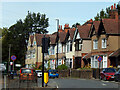
1
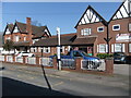
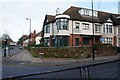
Merrick Lodge Hotel
A hotel on St. Nicholas Street, off Radford Road, a little to the north of Coventry city centre.
Image: © A J Paxton
Taken: 9 Mar 2014
0.01 miles
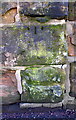
2
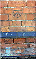
Benchmark on #93 St Nicholas Street
Ordnance Survey cut mark benchmark described on the Bench Mark Database at http://www.bench-marks.org.uk/bm92985
Image: © Roger Templeman
Taken: 12 Feb 2018
0.03 miles
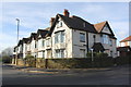
3
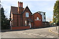
#93 St Nicholas Street
There is an OS benchmark Image on the right hand section of the building under the first storey door
Image: © Roger Templeman
Taken: 12 Feb 2018
0.03 miles
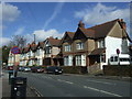
5
Radford Road, Coventry
A row of houses lines the east side of Radford Road, seen here from its junction with Light Lane. Radford Road forms part of the B4098 heading out of Coventry city centre towards the suburbs of Radford and Keresley.
Image: © Stephen McKay
Taken: 23 Sep 2021
0.03 miles
6
Benchmark on wall in front of #63 St Nicholas Street
Ordnance Survey cut mark benchmark described on the Bench Mark Database at http://www.bench-marks.org.uk/bm92984
Image: © Roger Templeman
Taken: 12 Feb 2018
0.04 miles
7
Junction of St Nicholas Street and Light Lane
There is an OS benchmark Image on the roadside wall about 8ft left of the gate near the right hand side of the image
Image: © Roger Templeman
Taken: 12 Feb 2018
0.04 miles
8
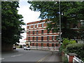
Office block, Sandy Lane
The former Daimler office block, dating from 1907-8, one of only 2 buildings on the Sandy Lane site to survive WWII.
Image: © E Gammie
Taken: 17 Jun 2012
0.04 miles
10
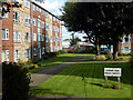
Elmwood Court, Coventry
Elmwood Court comprises 56 flats in a two-storey maisonette style, located to the east of St Nicholas Street and close to Coventry city centre.
Image: © Stephen McKay
Taken: 23 Sep 2021
0.05 miles