
IMAGES TAKEN NEAR TO
Hill Street, COVENTRY, CV1 4AT
Introduction
This page details the photographs taken nearby to Hill Street, CV1 4AT by members of the Geograph project.
The Geograph project started in 2005 with the aim of publishing, organising and preserving representative images for every square kilometre of Great Britain, Ireland and the Isle of Man.

There are currently over 7.5m images from over14,400 individuals and you can help contribute to the project by visiting https://www.geograph.org.uk
Image Map
Images are licensed for reuse under creativecommons.org/licenses/by-sa/2.0
Notes
- Clicking on the map will re-center to the selected point.
- The higher the marker number, the further away the image location is from the centre of the postcode.
Image Listing (626 Images Found)
Images are licensed for reuse under creativecommons.org/licenses/by-sa/2.0
Image
Details
Distance
1
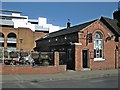
Coventry-The Gatehouse Tavern
In Lower Hill Street, the building was originally the Gatehouse of North Warwickshire Weaving and Spinning, Worsted and Woollen & Co factory which opened in 1866 and closed in 1963.
Image: © Ian Rob
Taken: 7 Mar 2011
0.01 miles
2
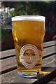
A pint from Wood Farm Brewery
The Gatehouse Tavern on Hill Street not only has a splendid garden - quite an oasis in the city centre - but also sells a splendid range of ales including this delicious looking pint from a local Warwickshire brewery.
Image: © Stephen McKay
Taken: 15 Sep 2012
0.02 miles
3
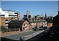
Coventry-Lower Hill Street
A view of the City Centre from the steps leading up to the foot/cycle bridge which crosses the Ring road to Upper Hill Street.
Image: © Ian Rob
Taken: 7 Mar 2011
0.02 miles
4
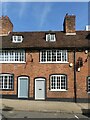
34-44 Hill Street ? part
A late 18th century terrace, one of very few of its type remaining in the city. The first floor would have formed workshops, either weaving or watch-making, as indicated by the large windows. Listed Grade II
Image: © Alan Murray-Rust
Taken: 23 Sep 2021
0.02 miles
5
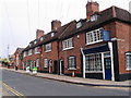
Hill Street, Coventry
A short terrace of 18th century houses at the corner of Hill Street and Ryley Street, restored in 1979. Grade II listed buildings.
Image: © E Gammie
Taken: 26 Sep 2008
0.02 miles
6
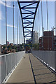
The Blue Bridge, Coventry
This £2 million footbridge across Ringway Hill Cross - part of Coventry's inner ring road - was opened in 2010. It connects Hill Street with Upper Hill Street. A bridge - in preference to a new subway - and the blue colour were selected in a public consultation.
Image: © Stephen McKay
Taken: 15 Sep 2012
0.02 miles
7
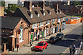
Hill Street, Coventry
Looking down from the footbridge over Coventry's inner ring road, the Gatehouse Tavern is on the immediate left.
Image: © Stephen McKay
Taken: 15 Sep 2012
0.02 miles
8
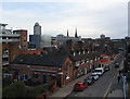
Hill Street and city centre
The view from the cycle and footbridge over the ring road. On the skyline, from left to right, are: Belgrade Plaza multi-storey car park; the rear of the Belgrade theatre and the upper part of Hillman House tower block; the dome and bulk of the West Orchards shopping centre; the spires of Holy Trinity and St Michaels; the upper part of the council offices tower block in Much Park Street.
Image: © E Gammie
Taken: 24 Dec 2011
0.02 miles
9
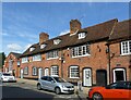
34-44 Hill Street
A late 18th century terrace, one of very few of its type remaining in the city. The first floor would have formed workshops, either weaving or watch-making, as indicated by the large windows. Listed Grade II
Image: © Alan Murray-Rust
Taken: 23 Sep 2021
0.02 miles
10
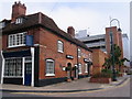
Ryley Street, Coventry
A short terrace of 18th century houses with grade II listed building status at the corner of Hill Street and Ryley Street, restored in 1979. Behind them is the multi-storey Belgrade Plaza car park.
Image: © E Gammie
Taken: 26 Sep 2008
0.03 miles