1
Dead end, Lower Holyhead Road
Up until the late 60's this as one of the main routes out of the city. A new ring road system was then built.Part of its wall can be seen at the top of the photograph.
Image: © Anthony Vosper
Taken: 27 Oct 2011
0.00 miles
2
Coventry Watch Museum Project plaque on 21 Lower Holyhead Road
One of the 20 plaques on the Coventry Watch Museum Heritage Trail
Image: © 360Libre
Taken: 30 Jan 2018
0.01 miles
3
Lower Holyhead Road
Part of Telford's original route.
Image: © Gerald England
Taken: 25 Sep 2021
0.01 miles
4
Benchmark on #9 Lower Holyhead Road
Ordnance Survey cut mark benchmark described on the Bench Mark Database at www.bench-marks.org.uk/bm89067
Image: © Roger Templeman
Taken: 19 Sep 2017
0.01 miles
5
My Dhabba restaurant at Spon Street / Lower Holyhead Road junction
There is an Ordnance Survey benchmark
Image on the right hand side of the Indian restaurant, left of the black downpipe
Image: © Roger Templeman
Taken: 19 Sep 2017
0.01 miles
6
Coventry- Spon Street
The tower block perhaps the only clue that this is Coventry.
Image: © Ian Rob
Taken: 7 Dec 2007
0.02 miles
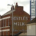
7
NESTL?'S MILK
'Richest in Cream'. Painted wall advert in Holyhead Road, Coventry.
At the time of this advert, Nestlé products were still primarily milk-based infant formula and condensed milk.
Image: © Alan Murray-Rust
Taken: 23 Sep 2021
0.02 miles
8
Coventry Foyer
Housing block in Lower Holyhead Road providing supported housing for young people, completed in 2002. On the left, on the corner of Spon Street, is 1 Lower Holyhead Road, now housing an Indian restaurant.
Image: © Ian Capper
Taken: 25 Sep 2021
0.02 miles
9
Coventry Watch Museum Project site of plaque on 21 Lower Holyhead Road
Although currently used as a modern Co-op funeral directors, this building is the last remnant of the once world-famous clock and watch manufacturers H. Williamsons. In the 19th century this building was once the front offices of a large watch manufacturers C. Errington, the factory being bought by Henry Williamson in 1898
A close-up of the plaque can be found here
Image
More details of Coventry's once thriving watch-making industry can be found by visiting http://www.coventrywatchmuseum.co.uk/
Image: © 360Libre
Taken: 20 Feb 2018
0.03 miles
10
180 - 181 and 182 Spon Street
Buildings on Spon Street. Nos 180 - 181, on the left, was originally a pub, The Rising Sun. The original Rising Sun dates from the mid 18th Century, but the building was demolished in 1896 and replaced by the present one. No 180, on the far left, was initially a shop but absorbed into the pub in 1957. The pub closed around 2010 and is now a steakhouse. No 182, Fairfax House, on the right, dates from 1901, replacing a school. Panels below the pair of front gables read: "Charity founded 1751", "Fairfax House" and "House rebuilt 1901". The building now houses a private members' club, Farifax Club.
Image: © Ian Capper
Taken: 25 Sep 2021
0.03 miles


