
IMAGES TAKEN NEAR TO
Lower Holyhead Road, COVENTRY, CV1 3AX
Introduction
This page details the photographs taken nearby to Lower Holyhead Road, CV1 3AX by members of the Geograph project.
The Geograph project started in 2005 with the aim of publishing, organising and preserving representative images for every square kilometre of Great Britain, Ireland and the Isle of Man.

There are currently over 7.5m images from over14,400 individuals and you can help contribute to the project by visiting https://www.geograph.org.uk
Image Map
Images are licensed for reuse under creativecommons.org/licenses/by-sa/2.0
Notes
- Clicking on the map will re-center to the selected point.
- The higher the marker number, the further away the image location is from the centre of the postcode.
Image Listing (650 Images Found)
Images are licensed for reuse under creativecommons.org/licenses/by-sa/2.0
Image
Details
Distance
1
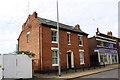
#9 Lower Holyhead Road (Errington House) and #11 Co-op Funeral Care
There is an Ordnance Survey benchmark Image on the front face of the house towards its left hand corner
Image: © Roger Templeman
Taken: 19 Sep 2017
0.00 miles
2
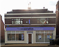
Coventry Watch Museum Project site of plaque on 21 Lower Holyhead Road
Although currently used as a modern Co-op funeral directors, this building is the last remnant of the once world-famous clock and watch manufacturers H. Williamsons. In the 19th century this building was once the front offices of a large watch manufacturers C. Errington, the factory being bought by Henry Williamson in 1898
A close-up of the plaque can be found here Image
More details of Coventry's once thriving watch-making industry can be found by visiting http://www.coventrywatchmuseum.co.uk/
Image: © 360Libre
Taken: 20 Feb 2018
0.01 miles
3
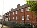
13-23 Lower Holyhead Road
Cottages with top floor workshops, either for weaving or watch-making. Dated 1819, Listed Grade II. This is the front view.
Image: © Alan Murray-Rust
Taken: 23 Sep 2021
0.01 miles
4
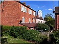
Ribbon weavers' houses with top shops, Holyhead Road, Coventry
A surviving row of houses of a type once common in Coventry, seen here from the rear. The ground and first floor of each house was a home; the second floor, typically reached by a ladder through a trapdoor, was the family's weaving-shed, with large windows to throw the greatest possible light onto the loom and the fine, detailed work that was carried out there.
Silk ribbon weaving was the main source of work in Coventry for over a century, until the Cobden-Chevalier free trade treaty with France in 1860 opened the British market to French silk goods at lower prices, leading to the collapse of the local industry and great distress to the weavers and their families.
This row of eighteen houses was built between 1819 and 1837. Nine survive; the others were demolished in the 1960s to make way for the ring road (behind the photographer), which reduced this section of Holyhead Road to a stub, cut off from the main road out of the city. http://planning.coventry.gov.uk/portal/servlets/AttachmentShowServlet?ImageName=844954
Image: © A J Paxton
Taken: 12 Jun 2021
0.01 miles
5
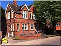
Quakers & rude boys: former Friends' Meeting House, Holyhead Road, Coventry
The meeting house on Holyhead Road was built in 1897 to a design by Charles Smith, at a time when the Quaker meeting in Coventry was growing and active in mission. It was the third Quaker meeting house that the city had known. The first had been a barn on a plot of land in nearby Hill Street, which was purchased by Quakers in 1668 as a burial ground (the modern meeting house, built in 1953, stands on the same plot, still in Quaker ownership). The second, which no longer exists, stood on Vicars Lane and was in use from 1689 until 1897.
By the 1940s the Quaker meeting had become too small to support the Holyhead Road building, which in more recent times has housed a variety of youth, community and arts organisations. https://heritage.quaker.org.uk/files/Coventry%20LM.pdf A plaque on the building (visible above the ramp) recalls its role as a rehearsal space for the emerging reggae and ska music scene in Coventry in the 1970s, which was to evolve into the city's distinctive 2-tone sound. Charley Anderson, later guitarist with The Selecter, played here and also worked at the centre as a youth worker. https://www.coventrytelegraph.net/whats-on/music-nightlife-news/lower-holyhead-road-building-crucial-11498284
Image: © A J Paxton
Taken: 12 Jun 2021
0.01 miles
6
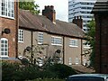
13-23 Lower Holyhead Road
Cottages with top floor workshops, either for weaving or watch-making. Dated 1819, Listed Grade II. This is the rear view.
Image: © Alan Murray-Rust
Taken: 23 Sep 2021
0.01 miles
7
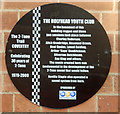
Coventry 2 Tone Trail Plaque - 16 Lower Holyhead road
Number 7 of the 11 plaques on the "2 Tone" trail celebrating the start of this 1980s genre of ska based music.
Image: © 360Libre
Taken: 30 Jan 2018
0.01 miles
8
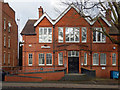
Coventry 2 Tone Trail site of Plaque - 16 Lower Holyhead road
This large Victorian building, at the centre of one of Coventry's conservation areas, has served many purposes since it was built in 1898. Originally a "Friends Meeting House". It went onto become a police social club, a youth club and is currently a community arts facility.
In its 1970s phase as a youth club it offered rehearsal space to a number of local up and coming bands bands including the Selector and Specials, both instigators of the successful ska music based 2-tome genre. The black "2 tone trail" plaque celebrates this
A close up of the plaque can be found here Image
Image: © 360Libre
Taken: 20 Feb 2018
0.01 miles
9
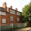
25-29 Lower Holyhead Road
Cottages with top floor workshops, either for weaving or watch-making. Early 19th century, complete by 1837, Listed Grade II. This is the front view.
Image: © Alan Murray-Rust
Taken: 23 Sep 2021
0.02 miles
10
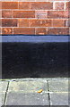
Benchmark on #9 Lower Holyhead Road
Ordnance Survey cut mark benchmark described on the Bench Mark Database at www.bench-marks.org.uk/bm89067
Image: © Roger Templeman
Taken: 19 Sep 2017
0.02 miles