IMAGES TAKEN NEAR TO
Roseway, NUNEATON, CV13 6HQ
Introduction
This page details the photographs taken nearby to Roseway, CV13 6HQ by members of the Geograph project.
The Geograph project started in 2005 with the aim of publishing, organising and preserving representative images for every square kilometre of Great Britain, Ireland and the Isle of Man.

There are currently over 7.5m images from over14,400 individuals and you can help contribute to the project by visiting https://www.geograph.org.uk
Image Map (Loading...)


Getting Data...Please wait
Leaflet Map data © OpenStreetMap
Images are licensed for reuse under creativecommons.org/licenses/by-sa/2.0
Notes
- Clicking on the map will re-center to the selected point.
- The higher the marker number, the further away the image location is from the centre of the postcode.
Image Listing (22 Images Found)
Images are licensed for reuse under creativecommons.org/licenses/by-sa/2.0
Image
Details
Distance
1
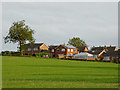
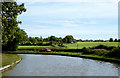
Housing and pasture near Stoke Golding in Leicestershire
A telephoto assisted image looking south-east towards Stoke Golding from near the Ashby Canal. Late evening September sunshine emphasises the golden hues. The housing (300 metres distant) is in Roseway.
Image: © Roger D Kidd
Taken: 24 Sep 2016
0.03 miles
2
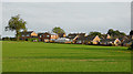
Pasture near Stoke Golding in Leicestershire
Looking south-east towards Stoke Golding from near the Ashby Canal. Late evening September sunshine emphasises the golden hues. The housing is in Roseway.
Image: © Roger D Kidd
Taken: 24 Sep 2016
0.10 miles
3
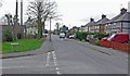
Hinckley Road in Stoke Golding
Looking west from the corner of Pine Close.
Image: © Mat Fascione
Taken: 26 Jan 2008
0.17 miles
4
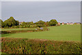
Farm land north of Stoke Golding, Leicestershire
Looking east-north-east from near the Ashby Canal, towards Dadlington. The road is Stoke Lane. Late evening September sunshine emphasises the golden hues.
Image: © Roger D Kidd
Taken: 24 Sep 2016
0.21 miles
5
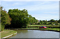
The Ashby Canal near Stoke Golding, Leicestershire
There is visitor mooring here for about four or five narrowboats. Failing this, crews wishing to use the village pubs can moor on the left and use the footpath across Foster's Bridge (No 27) and fields to the lane.
Image: © Roger D Kidd
Taken: 23 Sep 2016
0.22 miles
6
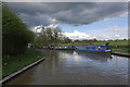
Ashby Canal, Dadlington
Between Stoke Golding and Dadlington the canal turns through this 90 degree bend. In this view an ominous cloud threatens overhead.
Image: © Stephen McKay
Taken: 10 Apr 2012
0.22 miles
7
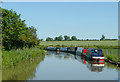
Moorings near Stoke Golding, Leicestershire
Visitor moorings are on the bend just ahead where Stoke Lane passes by the canal on the right. The canal is a very popular one for boaters because (at present) it has twenty-two miles with no locks to negotiate, and is mainly through rural and attractive countryside. It was opened in 1804, but never reached its intended destination of Ashby-de-la-Zouch.
Image: © Roger D Kidd
Taken: 16 Jun 2010
0.22 miles
8
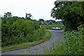
Stoke Lane south-west of Dadlington, Leicestershire
Looking south-west towards the Ashby Canal. There is good visitor mooring for four or five narrowboats here. The pubs in Stoke Golding are good.
Image: © Roger Kidd
Taken: 18 Jun 2010
0.22 miles
9
Moorings near Stoke Golding in Leicestershire
There is visitor mooring here on the Ashby Canal for about four or five narrowboats. Failing this, crews wishing to use the village pubs can moor by the towpath and use the footpath across Foster's Bridge (No 27) and fields to the lane.
Image: © Roger D Kidd
Taken: 23 Sep 2016
0.23 miles
10
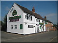
Stoke Golding: The White Swan
One of Stoke Golding's three pubs, The White Swan on the High Street seems to have had several variations on the name through the years. Old Ordnance Survey maps show it progressively as:-
1888: Swan
1903: Old Swan
1928: Old Swan
1962: The Swan Inn
1975: White Swan
1983: White Swan
Today it is The White Swan and an Everard's outlet.
Satellite imagery showing the roof layout suggests that this end is a more recent extension of the original building.
Image: © Nigel Cox
Taken: 11 Jul 2013
0.23 miles