IMAGES TAKEN NEAR TO
Paradise Street, COVENTRY, CV1 2XL
Introduction
This page details the photographs taken nearby to Paradise Street, CV1 2XL by members of the Geograph project.
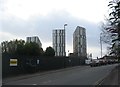
The Geograph project started in 2005 with the aim of publishing, organising and preserving representative images for every square kilometre of Great Britain, Ireland and the Isle of Man.

There are currently over 7.5m images from over14,400 individuals and you can help contribute to the project by visiting https://www.geograph.org.uk
Image Map
Images are licensed for reuse under creativecommons.org/licenses/by-sa/2.0
Notes
- Clicking on the map will re-center to the selected point.
- The higher the marker number, the further away the image location is from the centre of the postcode.
Image Listing (187 Images Found)
Images are licensed for reuse under creativecommons.org/licenses/by-sa/2.0
Image
Details
Distance
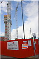
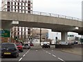
1
Construction site on west side of London Road
Image: © Roger Templeman
Taken: 31 Aug 2017
0.01 miles
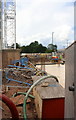
2
Paradise Street construction site at location of #58 London Road
Ordnance Survey documents indicate that in 1959 a benchmark levelled at 86.771m above Newlyn Datum was verified on #58 London Road, now demolished
Image: © Roger Templeman
Taken: 31 Aug 2017
0.01 miles
3
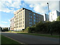
Merlin Point student accommodation, Deasy Road
Located in Coventry University Technology Park.
Image: © Christine Johnstone
Taken: 24 Sep 2021
0.06 miles
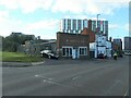
4
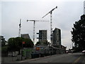
Gulson Road
The top of Gulson Road at its junction with London Road. The blocks under construction in the background are on the far side of London Road. The site of the car accessories business in the foreground is destined to become a residential development.
Image: © E Gammie
Taken: 23 Jun 2018
0.06 miles
5
Gulson Road
Gulson Road, near its junction with London Road. Three blocks of student accommodation on the far side of London Road.
Image: © E Gammie
Taken: 18 Dec 2019
0.06 miles
6
London Road (A4114), Coventry
Looking north.
Image: © JThomas
Taken: 19 Nov 2016
0.06 miles
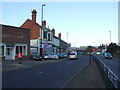
7
Buildings on London Road
Buildings on London Road (A4114), near the entrance to London Road cemetery.
Image: © E Gammie
Taken: 18 Dec 2019
0.06 miles
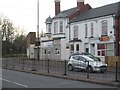
8
W. Smith & Son, 88 London Road, Coventry
Monumental masons and funeral directors, appropriately located near the north entrance to London Road cemetery.
Image: © Christine Johnstone
Taken: 24 Sep 2021
0.07 miles
10
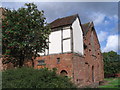
Whitefriars, south end
A Carmelite friary, founded 1342 with building continuing into the 15th century. The surviving building is the east range of the cloister, containing a cloister walk and part of the chapter house on the ground floor and a dormitory on the first floor. The roof has timbers similar to those in tithe barns which have been dated to trees felled in the last quarter of the 15th century. After the Dissolution, it was acquired by John Hales who converted it to a dwelling known as Hales Place.
The surviving building became part of the Workhouse in 1801 and continued as such through to the early 20th century, when it became a shelter for homeless men until the 1970s.
The building has grade I listed building status.
From the south: http://www.geograph.org.uk/photo/953309
From the north: http://www.geograph.org.uk/photo/953325
From the east: http://www.geograph.org.uk/photo/246381
A gateway to Whitefriars survives at the end of Whitefriars Lane: http://www.geograph.org.uk/photo/951430 , http://www.geograph.org.uk/photo/951451 and http://www.geograph.org.uk/photo/866143
Image: © E Gammie
Taken: 3 Sep 2008
0.09 miles