IMAGES TAKEN NEAR TO
Manor Road, COVENTRY, CV1 2GS
Introduction
This page details the photographs taken nearby to Manor Road, CV1 2GS by members of the Geograph project.
The Geograph project started in 2005 with the aim of publishing, organising and preserving representative images for every square kilometre of Great Britain, Ireland and the Isle of Man.

There are currently over 7.5m images from over14,400 individuals and you can help contribute to the project by visiting https://www.geograph.org.uk
Image Map
Images are licensed for reuse under creativecommons.org/licenses/by-sa/2.0
Notes
- Clicking on the map will re-center to the selected point.
- The higher the marker number, the further away the image location is from the centre of the postcode.
Image Listing (791 Images Found)
Images are licensed for reuse under creativecommons.org/licenses/by-sa/2.0
Image
Details
Distance
1
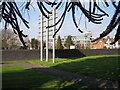
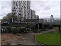
Open space off Manor Road
This bizarre residue of a garden, presumably, has been truncated by the ring road over the wall, and is dominated by a superb Monkey Puzzle tree (Araucaria araucana). The footbridge from Manor House Drive is off to the left Image The houses on the right are in St Patricks Road on the other side of Ringway St Patricks Image
Image: © Robin Stott
Taken: 16 Apr 2010
0.02 miles
3
Empty space, Manor Road
Also known as a 'development site'. The sign says it has 'planning for 179 student bedrooms'.
The location in 2008 : Image
Image: © E Gammie
Taken: 28 Jul 2012
0.03 miles
4
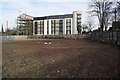
Demolition Site - #12 Manor Road was here
New apartment block on far side of Manor Road, behind the far wooden fence
Image: © Roger Templeman
Taken: 12 Feb 2018
0.03 miles
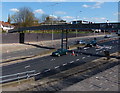
5
Footbridge over Coventry Ring Road
This footbridge long formed a welcome alternative to the dingy pedestrian subways under the ring road, though the nearby subway that connected the city centre with the railway station has now been replaced by a surface-level crossing.
Image: © A J Paxton
Taken: 14 Apr 2022
0.03 miles
6
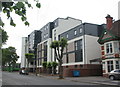
Park Road apartments
An apartment block at the corner of Park Road and Manor Road, replacing an Edwardian house and garden.
Image: © E Gammie
Taken: 23 Jun 2018
0.03 miles
7
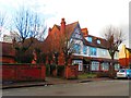
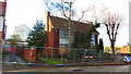
8 and 10 Manor Road, Coventry
Large Edwardian former houses which have been used as offices for many years. They now stand empty and I assume they are going to be demolished as part of the Friargate development. The rear of these buildings can be seen in Image] The wall on the left is the boundary to 12 Manor Road, at the corner of Park Road.
Image: © John Brightley
Taken: 6 Jan 2015
0.03 miles
8
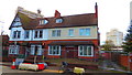
8 and 10 Manor Road, Coventry
A pair of former houses which have been used as offices for many years. Number 8 on the right was formerly the offices of Saunders Architects. The properties are now empty awaiting redevelopment.
Image: © John Brightley
Taken: 6 Jan 2015
0.03 miles
9

Park Road apartments
An apartment block at the corner of Park Road and Manor Road.
Image: © E Gammie
Taken: 23 Jun 2018
0.04 miles
10
4 and 6 Manor Road, Coventry
A pair of large former houses which have been used as offices for many years. Since the ring road was built adjacent in the early 1970's, the vehicle access has been via Copthall Terrace to the rear. They are now empty pending redevelopment.
Image: © John Brightley
Taken: 6 Jan 2015
0.04 miles