IMAGES TAKEN NEAR TO
Charterhouse Road, COVENTRY, CV1 2BJ
Introduction
This page details the photographs taken nearby to Charterhouse Road, CV1 2BJ by members of the Geograph project.
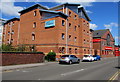
The Geograph project started in 2005 with the aim of publishing, organising and preserving representative images for every square kilometre of Great Britain, Ireland and the Isle of Man.

There are currently over 7.5m images from over14,400 individuals and you can help contribute to the project by visiting https://www.geograph.org.uk
Image Map
Images are licensed for reuse under creativecommons.org/licenses/by-sa/2.0
Notes
- Clicking on the map will re-center to the selected point.
- The higher the marker number, the further away the image location is from the centre of the postcode.
Image Listing (157 Images Found)
Images are licensed for reuse under creativecommons.org/licenses/by-sa/2.0
Image
Details
Distance
1
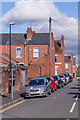
David Road
Early 20th Century street linking Charterhouse Road and St Margaret Road, connecting the end of Carmelite Road and Monks Road, the houses seen here.
Image: © Ian Capper
Taken: 24 Sep 2021
0.04 miles
2
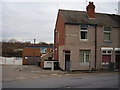
Former Corner Shop, Charterhouse Road
The extended pebble dash is the only clue that this was once a shop.
Image: © Anthony Vosper
Taken: 16 Feb 2012
0.05 miles
3
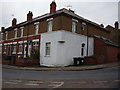
Former Corner Shop, Charterhouse Road
Slightly more obvious than its companion across the road.
This is just one of many shops no longer in existence in this square.
Image: © Anthony Vosper
Taken: 16 Feb 2012
0.05 miles
4
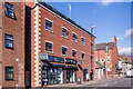
Gulson Lodge
Small retail/apartment block on Gulson Road built in the late 2010s.
Image: © Ian Capper
Taken: 24 Sep 2021
0.07 miles
5
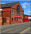
Buildbase Hirebase Electricbase in Coventry
Viewed across Gulson Road.
Image: © Jaggery
Taken: 18 Apr 2015
0.07 miles
6
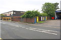
MGTS building, bridge of river, and tyre garage, Gulson Road
MGTS is Midland Group Training Services, the bridge is over River Sherbourne and the garage is Mr Tyre Ltd. There is an Ordnance Survey benchmark Image overpainted white at the right hand end of the bridge parapet
Image: © Roger Templeman
Taken: 8 Aug 2017
0.07 miles
7
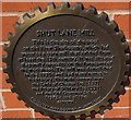
Shut Lane Mill marker, Coventry
Located on the Gulson Road side of this http://www.geograph.org.uk/photo/4444936 Unite Students building. The marker records the site of the pool on the River Sherbourne, which fed water to a corn mill that existed from at least the 13th century. The mill was demolished in the 1930s.
Image: © Jaggery
Taken: 18 Apr 2015
0.08 miles
8
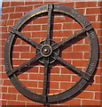
Old mills locations and dates marker, Gulson Road, Coventry
On a wall above this http://www.geograph.org.uk/photo/4444946 marker.
Image: © Jaggery
Taken: 18 Apr 2015
0.08 miles
9
Unite Students building in Coventry
Student accommodation viewed across Gulson Road.
Image: © Jaggery
Taken: 18 Apr 2015
0.08 miles
10
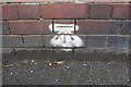
Benchmark on parapet of bridge on SE side of Gulson Road
Ordnance Survey cut mark benchmark described on the Bench Mark Database at www.bench-marks.org.uk/bm87427 . The bridge takes the road over River Sherbourne.
Image: © Roger Templeman
Taken: 8 Aug 2017
0.08 miles