IMAGES TAKEN NEAR TO
West Orchard Shopping Centre, Smithford Way, COVENTRY, CV1 1QX
Introduction
This page details the photographs taken nearby to West Orchard Shopping Centre, Smithford Way, CV1 1QX by members of the Geograph project.
The Geograph project started in 2005 with the aim of publishing, organising and preserving representative images for every square kilometre of Great Britain, Ireland and the Isle of Man.

There are currently over 7.5m images from over14,400 individuals and you can help contribute to the project by visiting https://www.geograph.org.uk
Image Map (Loading...)


Getting Data...Please wait
Leaflet Map data © OpenStreetMap
Images are licensed for reuse under creativecommons.org/licenses/by-sa/2.0
Notes
- Clicking on the map will re-center to the selected point.
- The higher the marker number, the further away the image location is from the centre of the postcode.
Image Listing (2019 Images Found)
Images are licensed for reuse under creativecommons.org/licenses/by-sa/2.0
Image
Details
Distance
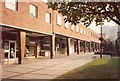
1
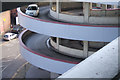
Spiral driveway up to West Orchards Car Park
West Orchards Shopping Centre covers the first three storeys of the building; consequently this is the way to access the car park above the shops. The outer (anti-clockwise) lane takes you up to the car park's lowest floor, and the inner (clockwise) lane takes you back down to street level.
Image: © Niki Walton
Taken: 9 Mar 2007
0.02 miles
2
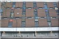
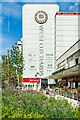
Mosaic detail in Cov Centre.
Detail of the 1960's mosaic on the side of Coventry City Library.
Image: © Richard Harrison
Taken: 10 Apr 2005
0.03 miles
3
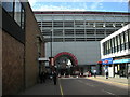
Coventry-West Orchards Shopping Centre
Entrance to the Shopping Centre off Ironmonger Row.
Image: © Ian Rob
Taken: 29 Aug 2009
0.03 miles
4
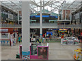
Lower Precinct, Coventry
The Lower Precinct was opened in 1958 as part of the wholesale redevelopment of Coventry's city centre following wartime devastation. The glass roof, however, is a much more recent addition. It claims to feature 25% of Coventry's shopping outlets. The circular café was originally called the Lady Godiva Café but is now part of the Caffè Nero chain.
Image: © Stephen McKay
Taken: 22 Sep 2018
0.03 miles
5
Smithford Way
The east side of Smithford Way before it was demolished for the construction of the West Orchards shopping centre. This is much as it looked when built in the late 1950s, with several small shops in a two-storey arcade. To the right, in the distance, is the later Coventry Point tower block in Market Way. In the foreground are four small racks for cycle parking and, partially visible, an open air chess board laid out on the paving, the chess pieces for which were loaned out from a nearby sports shop.
Taken on a Sunday predating the introduction of Sunday trading, hence the lack of people. Note also the lack of shuttering on the closed shops.
In 2010: http://www.geograph.org.uk/photo/2184480
Image: © E Gammie
Taken: Unknown
0.03 miles
6
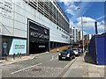
Car park access, West Orchards, Coventry
West Orchards is a multistorey shopping centre in the northeast quadrant of the precincts.
Image: © Robin Stott
Taken: 20 Jun 2022
0.03 miles
7
Smithford Way
The glass arcading, which covered this part of Smithford Way in front of West Orchards mall from the early 1990s, has now been removed after one of the panes shattered explosively.
The arcading in 2010: http://www.geograph.org.uk/photo/2184480
Image: © E Gammie
Taken: 19 Oct 2012
0.03 miles
8
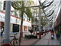
West Orchards, Smithford Way
The east side of Smithford Way, dominated by the West Orchards shopping mall. On the right are the remaining 1950s shops. The glass arcading was added when West Orchards was constructed circa 1990. The frontage of the mall is several feet west of the original building line of the 1950s shops, making Smithford Way much narrower than when built.
In the foreground is provision for cycle parking, one of which is actually in use.
In 1985: http://www.geograph.org.uk/photo/2184458
Image: © E Gammie
Taken: 3 Dec 2010
0.03 miles
9
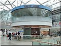
Caffe Nero in Coventry
Today this is a Caffe Nero in Lower Precinct, however, it used to be a round Wimpey cafe. The architectural style of this cafe reminds me of the TV series Thunderbird in which it was used.
Image: © Philip Halling
Taken: 13 Apr 2018
0.04 miles
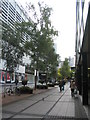
10
Smithford Way
Large flower bed in the pedestrianised Smithford Way, with West Orchards shopping centre in the background.
Image: © Ian Capper
Taken: 23 Sep 2021
0.04 miles