
IMAGES TAKEN NEAR TO
Coton Road, NUNEATON, CV11 5UF
Introduction
This page details the photographs taken nearby to Coton Road, CV11 5UF by members of the Geograph project.
The Geograph project started in 2005 with the aim of publishing, organising and preserving representative images for every square kilometre of Great Britain, Ireland and the Isle of Man.

There are currently over 7.5m images from over14,400 individuals and you can help contribute to the project by visiting https://www.geograph.org.uk
Image Map
Images are licensed for reuse under creativecommons.org/licenses/by-sa/2.0
Notes
- Clicking on the map will re-center to the selected point.
- The higher the marker number, the further away the image location is from the centre of the postcode.
Image Listing (65 Images Found)
Images are licensed for reuse under creativecommons.org/licenses/by-sa/2.0
Image
Details
Distance
1
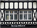
The King William IV (detail) in Nuneaton, Warwickshire
Shown here in 2013 (closed in 2012), the King William IV was set on fire by arsonists in 2015, had planning refused for conversion into six flats, and a further application in 2016 for a five flat conversion does not appear to have progressed according to a 2017 image on Geograph: http://www.geograph.org.uk/photo/5313229
Image: © Roger D Kidd
Taken: 19 Aug 2013
0.01 miles
2
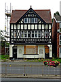
The King William IV in Nuneaton, Warwickshire
Shown here in 2013 (closed in 2012), the King William IV was set on fire by arsonists in 2015, had planning refused for conversion into six flats, and a further application in 2016 for a five flat conversion does not appear to have progressed according to a 2017 image on Geograph: http://www.geograph.org.uk/photo/5313229
Image: © Roger D Kidd
Taken: 19 Aug 2013
0.01 miles
3
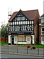
The King William IV in Nuneaton, Warwickshire
Shown here in 2013 (closed in 2012), the King William IV was set on fire by arsonists in 2015, had planning refused for conversion into six flats, and a further application in 2016 for a five flat conversion does not appear to have progressed according to a 2017 image on Geograph: http://www.geograph.org.uk/photo/5313229
Image: © Roger D Kidd
Taken: 19 Aug 2013
0.01 miles
4
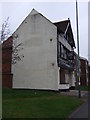
The King William IV public house
On Coton Road.
Image: © JThomas
Taken: 11 Mar 2017
0.01 miles
5
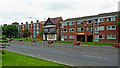
Coton Road in Nuneaton, Warwickshire
This is towards the southern end of the A444 Coton Road, including apartments and the former King William IV public house in 2013. The pub has since been attacked by arsonists, been refused planning permission for conversion into flats, and in 2016 applied for approval for an altered plan.
Image: © Roger D Kidd
Taken: 19 Aug 2013
0.01 miles
6
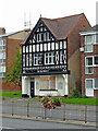
The King William IV in Nuneaton, Warwickshire
Shown here in 2013 (closed in 2012), the King William IV was set on fire by arsonists in 2015, had planning refused for conversion into six flats, and a further application in 2016 for a five flat conversion does not appear to have progressed according to a 2017 image on Geograph: http://www.geograph.org.uk/photo/5313229
Image: © Roger D Kidd
Taken: 19 Aug 2013
0.01 miles
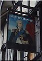
8
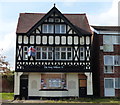
The former King William IV public house
A former public house located along the A444 Coton Road, it closed in 2012.
Image: © Mat Fascione
Taken: 28 Sep 2014
0.02 miles
9
Nuneaton : A444 Coton Road
A lorry on the side of Coton Road with traffic cones around it.
Image: © Lewis Clarke
Taken: 6 Feb 2012
0.04 miles
10
Nuneaton : Our Lady of the Angels Catholic Church
A church on Coton Road in Nuneaton.
Image: © Lewis Clarke
Taken: 6 Feb 2012
0.04 miles