IMAGES TAKEN NEAR TO
Villiers Street, NUNEATON, CV11 5PJ
Introduction
This page details the photographs taken nearby to Villiers Street, CV11 5PJ by members of the Geograph project.
The Geograph project started in 2005 with the aim of publishing, organising and preserving representative images for every square kilometre of Great Britain, Ireland and the Isle of Man.

There are currently over 7.5m images from over14,400 individuals and you can help contribute to the project by visiting https://www.geograph.org.uk
Image Map (Loading...)


Getting Data...Please wait
Leaflet Map data © OpenStreetMap
Images are licensed for reuse under creativecommons.org/licenses/by-sa/2.0
Notes
- Clicking on the map will re-center to the selected point.
- The higher the marker number, the further away the image location is from the centre of the postcode.
Image Listing (35 Images Found)
Images are licensed for reuse under creativecommons.org/licenses/by-sa/2.0
Image
Details
Distance
1
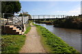
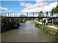
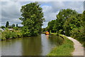
Coventry Canal in Nuneaton
Looking south-east towards Chilvers Coton. There are extensive allotments off to the right. There were already allotments shown here on Victorian maps. Catgallow's Bridge (No 20A) is ahead.
Image: © Roger Kidd
Taken: 22 Sep 2016
0.03 miles
2
Coventry Canal footbridge at Nuneaton, Warwickshire
Bridge 20A replaces the former wooden Catgallow's Bridge. https://www.coventrytelegraph.net/news/local-news/nuneaton-cat-gallows-why-called-13708180
Image: © Roger D Kidd
Taken: 25 Sep 2016
0.03 miles
3
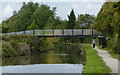
Catgallow's Bridge near Chilvers Coton in Nuneaton
This is the Coventry Canal, looking south-east as the waterway meanders towards Marston Junction and Bedworth. There are extensive allotments and housing off to the right, and housing off to the left. There were already allotments shown here on Victorian maps. Catgallow's Bridge is No 20A.
Apparently the original bridge was wooden. https://www.coventrytelegraph.net/news/local-news/nuneaton-cat-gallows-why-called-13708180
Image: © Roger Kidd
Taken: 22 Sep 2016
0.03 miles
4
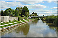
Footbridge over Coventry Canal near Villiers Street
See http://www.bench-marks.org.uk/bm51755 for description of Ordnance Survey benchmark on the bridge
Image: © Roger Templeman
Taken: 4 Oct 2016
0.04 miles
5
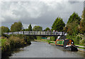
Coventry Canal: Bridge Number 20A: Catgallow's Bridge
From old large scale Ordnance Survey maps there was a canal crossing here called Catgallow's Bridge as early as 1889, when the surrounding land was just fields, and long before the houses on the east side and the allotments on the west side came. If this bridge did not exist people wishing to cross the canal would have to make lengthy detours as the next crossing to the north-west is Image some 700 metres away, and the next crossing to the south-east is Boot Bridge some 400 metres away. The photographer has no firm evidence that this is Bridge Number 20A, only that it falls between Bridge Numbers 20 and 21!
Image: © Nigel Cox
Taken: 11 Sep 2012
0.04 miles
6
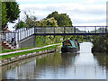
Footbridge No 20a across the Coventry Canal, Nuneaton
Image: © Mat Fascione
Taken: 13 Sep 2015
0.04 miles
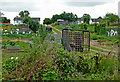
7
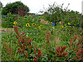
Allotments in Nuneaton, Warwickshire
The Coventry Canal passes about half a mile of allotments here, by Greenmoor Road.
Image: © Roger D Kidd
Taken: 19 Aug 2013
0.05 miles
8
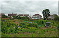
Allotments in Nuneaton, Warwickshire
The Coventry Canal passes about half a mile of allotments here. The housing is in Cox's Close, off Greenmoor Road.
Image: © Roger D Kidd
Taken: 19 Aug 2013
0.08 miles
9
Coventry Canal passing through Nuneaton
Image: © David Martin
Taken: 17 Jul 2016
0.09 miles
10
Allotments by the Coventry Canal in Nuneaton, Warwickshire
The Coventry Canal passes about half a mile of allotments here, by Greenmoor Road.
Image: © Roger D Kidd
Taken: 19 Aug 2013
0.09 miles