IMAGES TAKEN NEAR TO
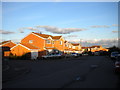
Grove Road, NUNEATON, CV10 8JX
Introduction
This page details the photographs taken nearby to Grove Road, CV10 8JX by members of the Geograph project.
The Geograph project started in 2005 with the aim of publishing, organising and preserving representative images for every square kilometre of Great Britain, Ireland and the Isle of Man.

There are currently over 7.5m images from over14,400 individuals and you can help contribute to the project by visiting https://www.geograph.org.uk
Image Map
Images are licensed for reuse under creativecommons.org/licenses/by-sa/2.0
Notes
- Clicking on the map will re-center to the selected point.
- The higher the marker number, the further away the image location is from the centre of the postcode.
Image Listing (16 Images Found)
Images are licensed for reuse under creativecommons.org/licenses/by-sa/2.0
Image
Details
Distance
1
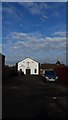
Arbury Baptist Church
The Baptist Church in Arbury caught in winter sunshine.
Image: © Peter Mackenzie
Taken: 24 Jan 2017
0.14 miles
2
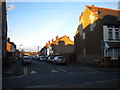
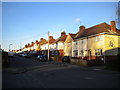
The south end of Westbury Road, Stockingford
Westbury Road is a largely residential street linking Arbury Road (foreground) with Haunchwood Road, and is part of the 20mph zone that covers part of Stockingford. The low winter Sun is catching the roofs of the houses, highlighting the way Westbury Road undulates.
Image: © Richard Vince
Taken: 2 Feb 2013
0.15 miles
3
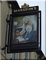
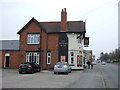
Sign for the Hearty Goodfellow public house, Stockingford, Nuneaton
Image: © JThomas
Taken: 11 Mar 2017
0.15 miles
5
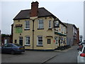
The Hearty Goodfellow public house, Stockingford, Nuneaton
On Arbury Road.
Image: © JThomas
Taken: 11 Mar 2017
0.15 miles
6
The Royal Oak Stockingford, Nuneaton
On Arbury Road.
Image: © JThomas
Taken: 11 Mar 2017
0.17 miles
7
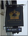
Sign for the Royal Oak Stockingford, Nuneaton
Image: © JThomas
Taken: 11 Mar 2017
0.17 miles
9
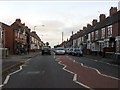
Cambridge Drive, Stockingford
Cambridge Drive is part of a (when compared with the rest of Stockingford) relatively modern housing development east of Westbury Road. The fairly large detached houses contrast with the Victorian and Edwardian terraced housing and more recent council homes in the surrounding area. The end of Sussex Close is visible on the left.
Image: © Richard Vince
Taken: 2 Feb 2013
0.18 miles
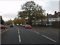
10
Westbury Road, Stockingford
Looking up Westbury Road towards Haunchwood Road from the end of St Paul's Road.
Image: © Richard Vince
Taken: 2 Feb 2013
0.19 miles