IMAGES TAKEN NEAR TO
Springwood Gate, NUNEATON, CV10 0NT
Introduction
This page details the photographs taken nearby to Springwood Gate, CV10 0NT by members of the Geograph project.
The Geograph project started in 2005 with the aim of publishing, organising and preserving representative images for every square kilometre of Great Britain, Ireland and the Isle of Man.

There are currently over 7.5m images from over14,400 individuals and you can help contribute to the project by visiting https://www.geograph.org.uk
Image Map
Images are licensed for reuse under creativecommons.org/licenses/by-sa/2.0
Notes
- Clicking on the map will re-center to the selected point.
- The higher the marker number, the further away the image location is from the centre of the postcode.
Image Listing (11 Images Found)
Images are licensed for reuse under creativecommons.org/licenses/by-sa/2.0
Image
Details
Distance
1
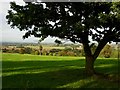
The Anker Valley
View across the valley of the River Anker from the outskirts of Nuneaton. The West Coast Main Line railway and the Coventry Canal run through the valley at this point. The Anker flows into the River Tame at Tamworth which is in turn a tributary of the Trent.
Image: © Stephen McKay
Taken: 30 Sep 2006
0.15 miles
2
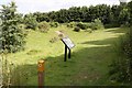
Oasis on the Quarryman's Walk Hartshill
The Quarryman's Walk passes through a community nature reserve at Caldecote Hill.
Image: © Richard Kay
Taken: 20 Jul 2008
0.15 miles
3
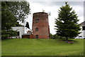
Windmill at Tuttle Hill
This disused windmill lies in the grounds of a private house, and is only visible through a wire fence from a perimeter footpath.
Image: © Richard Kay
Taken: 20 Jul 2008
0.15 miles
4
Nuneaton Fundamental Benchmark
Image: © Ian Paterson
Taken: 17 Mar 2020
0.21 miles
5
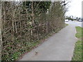
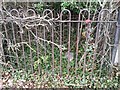
Sadly uncared for Fundamental Benchmark
Despite occupying a fairly prominent position, you could easily pass by this benchmark, specially fenced off to prevent damage to the structure.
See Image for a closer look and links to excellent descriptions.
Image: © Ian Paterson
Taken: 17 Mar 2020
0.21 miles
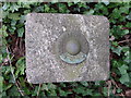
6
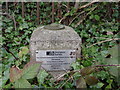
Nuneaton Fundamental Benchmark
Nuneaton Fundamental Benchmark. In a hedge on the north side of Camp Hill Road about 70m from the junction with Mancetter Road. FBMs are the key to the whole levelling of the UK. This is just the top of a fairly extensive underground structure on bedrock. These highly accurate height stations are still used today as the baseline to levelling. This fundamental bench mark was established in 1913 during the second geodetic levelling of England & Wales, and was levelled with a height of 459.8170 feet (140.1522 metres) above mean sea level (Newlyn datum). It was included on the Melbourne to Nuneaton and Warwick to Nuneaton levelling lines.
Image: © Shantavira
Taken: 4 Jan 2019
0.21 miles
7
Nuneaton Fundamental Benchmark
Nuneaton Fundamental Benchmark. In a hedge on the north side of Camp Hill Road about 70m from the junction with Mancetter Road. FBMs are the key to the whole levelling of the UK. This is just the top of a fairly extensive underground structure on bedrock. These highly accurate height stations are still used today as the baseline to levelling. This fundamental bench mark was established in 1913 during the second geodetic levelling of England & Wales, and was levelled with a height of 459.8170 feet (140.1522 metres) above mean sea level (Newlyn datum). It was included on the Melbourne to Nuneaton and Warwick to Nuneaton levelling lines. Close up shot at https://www.geograph.org.uk/photo/6017087
Image: © Shantavira
Taken: 4 Jan 2019
0.21 miles
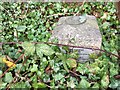
8
Top of Nuneaton Fundamental Benchmark
Sadly overgrown and easily missed despite the mark being fenced off.
For excellent details, see Image and Image
Image: © Ian Paterson
Taken: 17 Mar 2020
0.21 miles
9
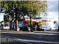
Camp Hill Service Station, Camp Hill Road
Texaco petrol filling station and 'Premier Shop Express' grocery store.
Image: © John Brightley
Taken: 20 Sep 2010
0.21 miles
10
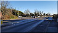
Caldecote Hill
The road junction at Caldecote Hill near to Camp Hill, Nuneaton.
Image: © Peter Mackenzie
Taken: 28 Nov 2017
0.23 miles