IMAGES TAKEN NEAR TO
Langley Gardens, MARGATE, CT9 3EB
Introduction
This page details the photographs taken nearby to Langley Gardens, CT9 3EB by members of the Geograph project.
The Geograph project started in 2005 with the aim of publishing, organising and preserving representative images for every square kilometre of Great Britain, Ireland and the Isle of Man.

There are currently over 7.5m images from over14,400 individuals and you can help contribute to the project by visiting https://www.geograph.org.uk
Image Map
Images are licensed for reuse under creativecommons.org/licenses/by-sa/2.0
Notes
- Clicking on the map will re-center to the selected point.
- The higher the marker number, the further away the image location is from the centre of the postcode.
Image Listing (25 Images Found)
Images are licensed for reuse under creativecommons.org/licenses/by-sa/2.0
Image
Details
Distance
1
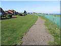
Path towards Cliftonville
Running alongside the road known as The Ridings and a miniature golf course on the right.
Image: © Nick Smith
Taken: 18 Oct 2008
0.06 miles
3
Path through to Monkton Gardens from The Ridings
Image: © Nick Smith
Taken: 18 Oct 2008
0.10 miles
5

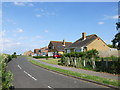
Princess Margaret Avenue, Cliftonville
Image: © Chris Whippet
Taken: 5 Jun 2014
0.11 miles
7
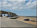
Cliftonville: Palm Bay
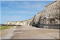
This is the eastern end of Palm Bay showing the cliffs and sea defences leading round to Foreness Point. The rectangular black slab on the top of the cliff is the boundary wall of Southern Water's construction site where improvements are currently being made to the Foreness Point Wastewater Treatment Works.
Image: © Nigel Cox
Taken: 7 Jun 2007
0.18 miles
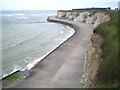
9
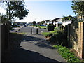
Prince's Walk to Friends Gap Landing Ramp
This access road leads from Palm Bay Avenue down to the promenade and sea wall near Cliftonville. In the background is a landing ramp leading into Palm Bay, only used at low tide.
Image: © David Anstiss
Taken: 8 May 2011
0.19 miles
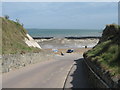
10
Waterski and Jetski Hire point, Palm Bay
This cabin hires out waterskis and jetskis to use in the bay at high tide.
Seen from the sea wall promenade leading from Cliftonville towards Margate.
Image: © David Anstiss
Taken: 8 May 2011
0.20 miles