IMAGES TAKEN NEAR TO
Ethelbert Crescent, MARGATE, CT9 2DP
Introduction
This page details the photographs taken nearby to Ethelbert Crescent, CT9 2DP by members of the Geograph project.
The Geograph project started in 2005 with the aim of publishing, organising and preserving representative images for every square kilometre of Great Britain, Ireland and the Isle of Man.

There are currently over 7.5m images from over14,400 individuals and you can help contribute to the project by visiting https://www.geograph.org.uk
Image Map
Images are licensed for reuse under creativecommons.org/licenses/by-sa/2.0
Notes
- Clicking on the map will re-center to the selected point.
- The higher the marker number, the further away the image location is from the centre of the postcode.
Image Listing (142 Images Found)
Images are licensed for reuse under creativecommons.org/licenses/by-sa/2.0
Image
Details
Distance
1

William Foord-Kelcey Plaque
On Image
See http://en.wikipedia.org/wiki/William_Foord-Kelcey for more details on this cricketer and mathematics professor!
Image: © David Anstiss
Taken: 9 Apr 2013
0.01 miles
2
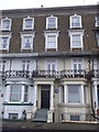
7 Ethelbert Crescent, Cliftonville
One of the terrace of houses along a road.
Has Image on the side.
Image: © David Anstiss
Taken: 9 Apr 2013
0.01 miles
4
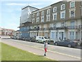
Ethelbert Crescent
I wonder what happened to this end of the terrace, as it has been reduced to the ground floor and basement.
Image: © John Baker
Taken: 28 Jul 2013
0.03 miles
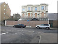
5
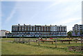
26 Ethelbert Crescent
Thanet District Council has set up a long-term programme called ‘Live Margate’ that involves buying existing properties and turning them into quality family homes. The buildings that are being targeted are those that have been derelict and unoccupied for years and this is one of them, partly hidden from view by scaffolding and polythene sheeting http://thanet.gov.uk/the-thanet-magazine/campaigns/live-margate/
Image: © John Baker
Taken: 22 Jun 2014
0.03 miles
6

Mural on the end of Ethelbert Crescent
Also a ghost sign for EUROMART
Image: © Keith Edkins
Taken: 24 Jun 2015
0.03 miles
7
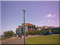
Thanet Coastal Path approaching Newgate Gap Bridge
This is the Thanet Coastal Path as it approaches Newgate Gap Bridge (just in front of where the people can be seen walking in the background) and the new seaside flats featured in Image The structure on the extreme right of the image is a shelter. View taken looking east as the crow flies.
Image: © Robert Lamb
Taken: 15 Jun 2008
0.05 miles
8
Elizabeth Anne Nursing and Residential Care Home, 64, Elgar Road
The name of this former institution can be seen on the black “triangle” above the hoarding. This was probably situated over the front entrance. The boarded up windows, on the first floor, indicate that the building is disused.
Image: © John Baker
Taken: 13 Jan 2016
0.05 miles
9
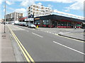
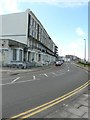
Looking ESE along Ethelbert Crescent
Just beyond Bugsy’s Tenpin Bowling establishment was Franks Nightclub. At present, the frontage is clad in scaffolding, above hoarding, which hides the ground floor. However, planning permission has been granted by Thanet District Council under application number F/TH/17/0132 for the “change of use from nightclub (use class sui-generis) to restaurant (use class A3), offices and [a] 1 3-bed self contained flat.
Image: © John Baker
Taken: 30 Jul 2017
0.05 miles
10
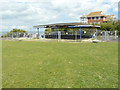
Derelict shelter
Totally surrounded by a fence so as to keep the public out, as it is a dangerous structure.
Image: © John Baker
Taken: 30 Jul 2017
0.05 miles