IMAGES TAKEN NEAR TO
Sandhurst Place, MARGATE, CT9 1EF
Introduction
This page details the photographs taken nearby to Sandhurst Place, CT9 1EF by members of the Geograph project.
The Geograph project started in 2005 with the aim of publishing, organising and preserving representative images for every square kilometre of Great Britain, Ireland and the Isle of Man.

There are currently over 7.5m images from over14,400 individuals and you can help contribute to the project by visiting https://www.geograph.org.uk
Image Map
Images are licensed for reuse under creativecommons.org/licenses/by-sa/2.0
Notes
- Clicking on the map will re-center to the selected point.
- The higher the marker number, the further away the image location is from the centre of the postcode.
Image Listing (355 Images Found)
Images are licensed for reuse under creativecommons.org/licenses/by-sa/2.0
Image
Details
Distance
1
Building construction, Northdown Road
The building is being erected on the site of the former Inland Revenue building. Planning permission has been granted by Thanet District Council under application number F/TH/09/0808 for the "erection of seven 4 bed houses, five 3 bed houses, two 4 storey buildings containing 23, 2 and 3 bed flats with associated access and parking following demolition of existing building". The completed building is known as Image
Image: © John Baker
Taken: 28 Jul 2013
0.02 miles
2
Sandhurst Place, Northdown Road
Almost a year ago, the site was Image
Image: © John Baker
Taken: 22 Jun 2014
0.02 miles
3
Margate Cave
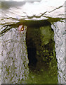
Rediscovered in 1798, these caves are reputed to be of Saxon origin, consisting of a series of natural passages, which have been artificially enlarged, perhaps for the chalk. They contain some unusual paintings created after the rediscovery. The Margate Cave had to be closed in 2004 because of the instability of the soft chalk. There was subsidence which made the visit unsafe. In 1914 a new entrance was made from the cellar of the vicarage, which is the entrance used today. The vicarage was part of Northumberland House and was destroyed in World War II. The caves have been connected to Vortigern who supposedly gave the area around Margate to the Saxons as a reward for helping him fight the Picts and Scots.
Image: © Jo and Steve Turner
Taken: 5 Jun 1979
0.04 miles
4
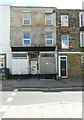
A derelict shop, Northdown Road
It might have once born the number 22 on its frontage.
Image: © John Baker
Taken: 30 Jul 2017
0.04 miles
5
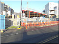
Margate Caves, Northdown Road
Planning permission has been granted by Thanet District Council under application number F/TH/15/0121for the “erection of single storey visitor centre with community space and café (Use Class D1), together with excavation of land to form ramped access to front entrance”.
This is the Image
Image: © John Baker
Taken: 9 Dec 2018
0.04 miles
6

Margate Caves visitor centre, Northdown Road
This was Image, when the visitor centre was being erected and before the ramped access had been created.
Image: © John Baker
Taken: 15 Oct 2019
0.04 miles
7
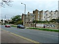
Site of Margate Caves
Taken on the B2055 where Northdown Road meets Trinity Square. Trinity Memorial Gardens visible in background on left.
Image: © Clint Mann
Taken: 1 Nov 2014
0.05 miles
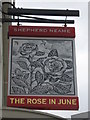
8
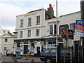
The Rose in June, Public House, Margate
At the end of Trinity Square.
Image: © David Anstiss
Taken: 11 Sep 2010
0.05 miles