IMAGES TAKEN NEAR TO
King Street, MARGATE, CT9 1BZ
Introduction
This page details the photographs taken nearby to King Street, CT9 1BZ by members of the Geograph project.
The Geograph project started in 2005 with the aim of publishing, organising and preserving representative images for every square kilometre of Great Britain, Ireland and the Isle of Man.

There are currently over 7.5m images from over14,400 individuals and you can help contribute to the project by visiting https://www.geograph.org.uk
Image Map
Images are licensed for reuse under creativecommons.org/licenses/by-sa/2.0
Notes
- Clicking on the map will re-center to the selected point.
- The higher the marker number, the further away the image location is from the centre of the postcode.
Image Listing (583 Images Found)
Images are licensed for reuse under creativecommons.org/licenses/by-sa/2.0
Image
Details
Distance
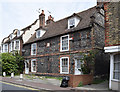
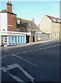
1
Cottages, Alkali Row, Margate
The name Alkali Row came from seaweed burners in the late 18th and early 19th century. Seaweed was burnt to a powder called alkali or, more recently, potash.
Image: © Robin Webster
Taken: 20 Mar 2016
0.02 miles
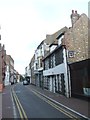
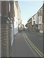
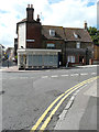
2
King Street, Margate
Flint cottages in Old Town.
Image: © pam fray
Taken: 19 Jun 2013
0.02 miles
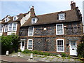
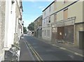
3
Flint cottages in King Street
Probably 17th century. The listed building record refers to a modern office frontage - this was presumably restored away in 1982 (per the plaque in the middle). Grade II listed.
Image: © Keith Edkins
Taken: 20 Jun 2015
0.02 miles
4
King Street, Margate
King Street was closed, for this day only, so that work could be carried out on a scaffolding-clad building with the aid of a crane (which was mounted on the back of the lorry with its lights on).
Image: © John Baker
Taken: 5 Sep 2012
0.02 miles
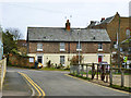
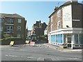
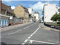
5
King Street
The unoccupied launderette is at number 30, while two doors away is Kingfisheries at number 34. Kingfisheries’ website describes the shop as stocking
“quality fishing products for sea and freshwater fishing” http://www.kingfisheries.co.uk/
Planning permission has been granted by Thanet District Council under application number F/TH/10/0973 for the “erection of a first floor extension”.
Image: © John Baker
Taken: 28 Jul 2013
0.02 miles
6
King Street, Margate
Ahead is lorry described in Image but seen from the other direction and showing the building, clad in scaffolding, which was the reason for the street's closure.
Image: © John Baker
Taken: 5 Sep 2012
0.02 miles
7
Restoration of 92,Trinity Square
Compared with Image, there is now an open door in the wooden boards hiding the front of the building. The white notice to the right of the door indicated that restoration was taking place. This image shows number 92 after restoration when I was Image
Image: © John Baker
Taken: 13 Jan 2016
0.03 miles
8
Looking northwest from King Street
The house, to the right of The Denture Shop, is number 92, Trinity Square. This image shows the Image
Image: © John Baker
Taken: 30 Jul 2017
0.03 miles
9
Trinity Square
Seen from its junction with King Street. The light-coloured brick building on the left was being erected when I photographed Image from further away.
Image: © John Baker
Taken: 28 Jul 2013
0.03 miles