IMAGES TAKEN NEAR TO
The Square, BIRCHINGTON, CT7 9AW
Introduction
This page details the photographs taken nearby to The Square, CT7 9AW by members of the Geograph project.
The Geograph project started in 2005 with the aim of publishing, organising and preserving representative images for every square kilometre of Great Britain, Ireland and the Isle of Man.

There are currently over 7.5m images from over14,400 individuals and you can help contribute to the project by visiting https://www.geograph.org.uk
Image Map
Images are licensed for reuse under creativecommons.org/licenses/by-sa/2.0
Notes
- Clicking on the map will re-center to the selected point.
- The higher the marker number, the further away the image location is from the centre of the postcode.
Image Listing (103 Images Found)
Images are licensed for reuse under creativecommons.org/licenses/by-sa/2.0
Image
Details
Distance
1
![Birchington-on-Sea houses [2]](https://s3.geograph.org.uk/geophotos/07/06/02/7060215_a66f63df_120x120.jpg)
Birchington-on-Sea houses [2]
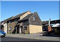
Grove house, number 215 Canterbury Road, was built in the mid 18th century. Constructed of brown brick with red brick dressings under a renewed tile roof with shaped Dutch gables. Listed, grade II, with details at: https://historicengland.org.uk/listing/the-list/list-entry/1203367
Birchington-on-Sea is a seaside village some 7 miles east of Herne Bay and some 3½ miles west of Margate. There is evidence of occupation from the Iron Age. As a resort, the village has a tourism based economy, with hotels, caravan parks and leisure attractions. Many retirees make the village their home.
Image: © Michael Dibb
Taken: 7 Sep 2021
0.00 miles
3
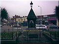
Well in the Village Square
This well can be found dead opposite Birchington Roundabout and is only just about inside the bottom-left hand area of the square. The well's cup, so I'm told, was originally still attached to it, but perhaps somebody clambered over the low railings and stole it. The lantern at the top of the well is unlit at night, so perhaps it is more of an ornamental feature rather than an illuminator - I didn't look to see if there was still a lamp in it. This view was taken looking strictly north, more or less parallel with my shot of All Saints Church from Albion Road.
Image: © Robert Lamb
Taken: 8 Jun 2008
0.01 miles
4
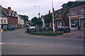
The well in the village square, looking east-northeast
Here is an alternative view of the well in Birchington village square, taken looking east-northeast in the direction of Margate from Canterbury Road (A28). Three roads meet here - Station Road ends just out of shot to the left after passing through Birchington village centre, Canterbury Road comes from behind me and cuts across the image and around the corner by the well and heads towards Margate, whilst Park Lane from Manston Airport ends just to my right. The road junction is at the bottom edge of square TR3069.
Image: © Robert Lamb
Taken: 8 Jun 2008
0.01 miles
5
![Birchington-on-Sea buildings [1]](https://s2.geograph.org.uk/geophotos/07/06/02/7060210_b41595ec_120x120.jpg)
Birchington-on-Sea buildings [1]
Birchington Methodist Church, Canterbury Road, was built in 1830. Constructed of brick under a slate roof. Crenelated with a clock tower. Listed, grade II, with details at: https://historicengland.org.uk/listing/the-list/list-entry/1088986
Birchington-on-Sea is a seaside village some 7 miles east of Herne Bay and some 3½ miles west of Margate. There is evidence of occupation from the Iron Age. As a resort, the village has a tourism based economy, with hotels, caravan parks and leisure attractions. Many retirees make the village their home.
Image: © Michael Dibb
Taken: 7 Sep 2021
0.02 miles
6
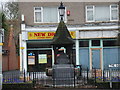
Well on Birchington Roundabout viewed from the opposite side of the road
This is the view of the well on Birchington Roundabout looking from the opposite side of The Square (and taken with my new Sony digital camera), looking towards Park Lane. The shop behind the well is a Chinese takeaway called the New Dragon and just out of shot to the left is a Thai restaurant. I'm unsure what the shop to the right of the New Dragon was, but it has clearly been closed for quite some time as it is beginning to look rather derelict and run down. View taken looking south.
Image: © Robert Lamb
Taken: 14 Dec 2008
0.02 miles
7
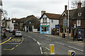
A28 at Birchington
Shops and other premises at The Square, Birchington.
Image: © Martin Addison
Taken: 21 Mar 2015
0.02 miles
8
![Birchington-on-Sea buildings [2]](https://s1.geograph.org.uk/geophotos/07/06/02/7060213_3abb5a33_120x120.jpg)
Birchington-on-Sea buildings [2]
The Smugglers Restaurant at number 212 Canterbury Road was built in the late 17th century. Constructed of brown brick with red brick dressings under a tile roof with shaped Dutch gables. Listed, grade II, with details at: https://historicengland.org.uk/listing/the-list/list-entry/1203373
Birchington-on-Sea is a seaside village some 7 miles east of Herne Bay and some 3½ miles west of Margate. There is evidence of occupation from the Iron Age. As a resort, the village has a tourism based economy, with hotels, caravan parks and leisure attractions. Many retirees make the village their home.
Image: © Michael Dibb
Taken: 7 Sep 2021
0.03 miles
9
![Birchington-on-Sea features [1]](https://s0.geograph.org.uk/geophotos/07/06/02/7060216_479dfae9_120x120.jpg)
Birchington-on-Sea features [1]
On a small traffic island is this delightful drinking fountain and horse trough. The fountain, in polished granite, was erected in 1909.
Birchington-on-Sea is a seaside village some 7 miles east of Herne Bay and some 3½ miles west of Margate. There is evidence of occupation from the Iron Age. As a resort, the village has a tourism based economy, with hotels, caravan parks and leisure attractions. Many retirees make the village their home.
Image: © Michael Dibb
Taken: 7 Sep 2021
0.03 miles
10
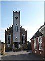
Birchington Methodist Church
The plaque on the tower reads "Methodist Chapel 1830". To the right of the picture is a building with another plaque reading "Wesleyan Schoolroom 1928".
Image: © pam fray
Taken: 22 Mar 2009
0.03 miles