IMAGES TAKEN NEAR TO
The Length, BIRCHINGTON, CT7 0PW
Introduction
This page details the photographs taken nearby to The Length, CT7 0PW by members of the Geograph project.
The Geograph project started in 2005 with the aim of publishing, organising and preserving representative images for every square kilometre of Great Britain, Ireland and the Isle of Man.

There are currently over 7.5m images from over14,400 individuals and you can help contribute to the project by visiting https://www.geograph.org.uk
Image Map (Loading...)


Getting Data...Please wait
Leaflet Map data © OpenStreetMap
Images are licensed for reuse under creativecommons.org/licenses/by-sa/2.0
Notes
- Clicking on the map will re-center to the selected point.
- The higher the marker number, the further away the image location is from the centre of the postcode.
Image Listing (40 Images Found)
Images are licensed for reuse under creativecommons.org/licenses/by-sa/2.0
Image
Details
Distance
1
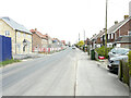
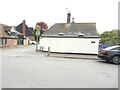
Building site, The Length
Planning permission has been granted by Thanet District Council under application number F/TH/19/1231 for the “erection of 34 dwellings, together with associated landscaping, parking and access”.
The development has been named The Stables.
Image: © John Baker
Taken: 2 May 2022
0.04 miles
2
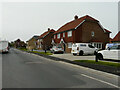
The Length
A similar view of Image from the west-south-west; the development has been named The Stables. At far end of the road is the tower of St Nicholas 'church.
Image: © John Baker
Taken: 30 Apr 2023
0.05 miles
3
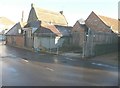
The Forge, The Length
Seen from Manor Road, planning permission has been granted by Thanet District Council under application number L/TH/06/1050 for the “demolition of existing garage and lean-to and erection of single storey extension together with insertion of glazed wall, one roof light and internal alterations”,
Image: © John Baker
Taken: 11 Dec 2013
0.08 miles
4
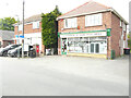
St Nicholas at Wade post office, The Length
Little appears to have changed to the building since Chris Downer’s view of Image in June 2012.
Image: © John Baker
Taken: 2 May 2022
0.08 miles
5
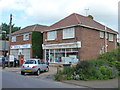
St. Nicholas-at-Wade: the post office
A village store and post office, on the main street, called The Length, in the centre of the village.
Image: © Chris Downer
Taken: 18 Jun 2012
0.08 miles
6
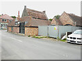
The Forge, The Length
Viewed from Manor Road, this was Image, when it was undergoing external and internal alterations. This view of Image shows the frontage of the premises.
Image: © John Baker
Taken: 18 Sep 2022
0.08 miles
7
The Forge, The Length
In December 2013, Image was undergoing work for a single storey extension together with the insertion of a glazed wall, one roof light and internal alterations.
Image: © John Baker
Taken: 2 May 2022
0.08 miles
8
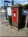
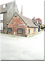
St. Nicholas-at-Wade: postbox № CT7 44
This George V-reign postbox is set into a shapely brick pillar outside Image
Image: © Chris Downer
Taken: 18 Jun 2012
0.09 miles
10
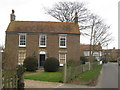
Myrtle Villa, St. Nicholas at Wade
House on Manor Road.
Image: © David Anstiss
Taken: 6 Feb 2011
0.10 miles