IMAGES TAKEN NEAR TO
Rose Way, HERNE BAY, CT6 6FR
Introduction
This page details the photographs taken nearby to Rose Way, CT6 6FR by members of the Geograph project.
The Geograph project started in 2005 with the aim of publishing, organising and preserving representative images for every square kilometre of Great Britain, Ireland and the Isle of Man.

There are currently over 7.5m images from over14,400 individuals and you can help contribute to the project by visiting https://www.geograph.org.uk
Image Map
Images are licensed for reuse under creativecommons.org/licenses/by-sa/2.0
Notes
- Clicking on the map will re-center to the selected point.
- The higher the marker number, the further away the image location is from the centre of the postcode.
Image Listing (44 Images Found)
Images are licensed for reuse under creativecommons.org/licenses/by-sa/2.0
Image
Details
Distance
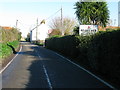
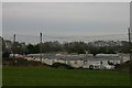
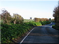
4
Reculver Lane enters Reculver
The road goes no further than Reculver - return the way you came if a motor vehicle.
Image: © Robin Webster
Taken: 4 Jun 2015
0.09 miles
6
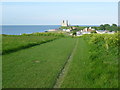
St Mary's Abbey from Reculver Country Park
In 1809 the Vicar of the parish demolished all of St Mary's Abbey on the cliff top at Reculver, apart from the towers. Trinity House intervened to ensure that the towers were preserved as a navigational aid. This is the view from Reculver Country Park.
For a full history of the Roman settlement, the building of St Mary's Abbey and its demolition see http://en.wikipedia.org/wiki/Reculver
Image: © Marathon
Taken: 4 May 2014
0.12 miles
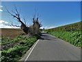
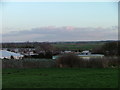
8
Blue Dolphin Park
A mobile homes site at Reculver.
Image: © David Kemp
Taken: 20 Oct 2012
0.14 miles
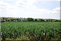
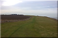
10
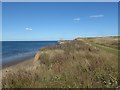
Reculver Country Park above Bishopstone Cliffs
This is the Thanet Coastal Path as it heads to Reculver. The same route is followed by the Saxon Shore Way. The remains of St Mary's Church can be seen in the distance. The towers of the ruined church are a landmark for miles around. For a close up of the church see https://www.geograph.org.uk/photo/6579754
Image: © Marathon
Taken: 20 Aug 2020
0.15 miles