IMAGES TAKEN NEAR TO
Dence Close, HERNE BAY, CT6 6BH
Introduction
This page details the photographs taken nearby to Dence Close, CT6 6BH by members of the Geograph project.
The Geograph project started in 2005 with the aim of publishing, organising and preserving representative images for every square kilometre of Great Britain, Ireland and the Isle of Man.

There are currently over 7.5m images from over14,400 individuals and you can help contribute to the project by visiting https://www.geograph.org.uk
Image Map
Images are licensed for reuse under creativecommons.org/licenses/by-sa/2.0
Notes
- Clicking on the map will re-center to the selected point.
- The higher the marker number, the further away the image location is from the centre of the postcode.
Image Listing (96 Images Found)
Images are licensed for reuse under creativecommons.org/licenses/by-sa/2.0
Image
Details
Distance
1

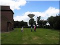
View of Herne Bay Water Tower from field next to Osborne Gardens Beltinge Village
This shot was taken in the field off the back of Osborne Gardens in the Village of Beltinge. On the horizon centre left you can see Herne Bay water tower, and St Barts steeple. This view will soon be impossible as developers are building another 1,300 home estate on this field. Villagers are campaigning to build a bypass bridge near the Thanet Way to divert the mass traffic from this development away from the town.
Image: © Matt Allsop
Taken: 17 Apr 2020
0.04 miles
2
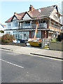
48, Beacon Hill
Planning permission was granted by Canterbury City Council under application number CA//18/00404 for a “proposed inset balcony to front elevation and rear dormer window”.
Image: © John Baker
Taken: 1 Jul 2018
0.07 miles
4
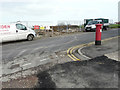
Closure of a footpath
Seen from the end of Hill Top Road, at its junction with Beacon Hill, an area on the other side of the road has been fenced off and a notice affixed to the fence advising the public that the footpath (is) closed. This presumably relates to Image
Image: © John Baker
Taken: 25 Jan 2016
0.11 miles
5

View up Beacon Hill
This is effectively the reverse view of Image
Image: © David Martin
Taken: 18 Mar 2023
0.12 miles
6
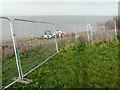
Repairs to a footpath
That runs through an area known as The Downs. This presumably relates to Image
Image: © John Baker
Taken: 25 Jan 2016
0.12 miles
7

East end of Herne Bay
Houses on Beacon Hill above the grassy area.
Image: © E Gammie
Taken: 6 Jul 2010
0.13 miles
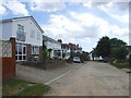
8
The Downs, Herne Bay
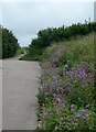
One of the paths through this coastal park area near Beltinge. It is abundant in wildflowers and the plants on the right of the path are mallow.
Image: © pam fray
Taken: 29 Jun 2021
0.13 miles
10
Former Beacon Hill Lodge Nursing Home, 18 Beacon Hill
Planning permission was granted by Canterbury City Council under application number CA//16/00426 for the “demolition of two-storey rear extension and erection of three-storey rear extension with internal alterations to provide twenty extra care apartments with associated multipurpose treatment, laundry and catering facilities and residents lounge area”.
This is the former nursing home as viewed from Belle View Road showing many of the boarded up doors that once led into the rear extension.
Image: © John Baker
Taken: 1 Jul 2018
0.14 miles