IMAGES TAKEN NEAR TO
Canterbury Road, HERNE BAY, CT6 5TD
Introduction
This page details the photographs taken nearby to Canterbury Road, CT6 5TD by members of the Geograph project.
The Geograph project started in 2005 with the aim of publishing, organising and preserving representative images for every square kilometre of Great Britain, Ireland and the Isle of Man.

There are currently over 7.5m images from over14,400 individuals and you can help contribute to the project by visiting https://www.geograph.org.uk
Image Map (Loading...)


Getting Data...Please wait
Leaflet Map data © OpenStreetMap
Images are licensed for reuse under creativecommons.org/licenses/by-sa/2.0
Notes
- Clicking on the map will re-center to the selected point.
- The higher the marker number, the further away the image location is from the centre of the postcode.
Image Listing (30 Images Found)
Images are licensed for reuse under creativecommons.org/licenses/by-sa/2.0
Image
Details
Distance
1
Parsonage Road, Eddington and its history
This is looking east along the road which is still little more than the farm track it was a century ago when the land around was part of Parsonage Farm. That was before Herne Bay was built and when the farm consisted of a patchwork of fields between the old Herne village Image and the sea shore. Back then, the great Parsonage Farmhouse and its buildings stood immediately to the right of the picture beside this road/track which leads, as it still does today, to one of the farm's surviving fields Image See Gallery at: http://www.geograph.org.uk/gallery/trail_of_a_kentish_farming_family_9094
(background family story http://books.google.com/books?id=hrpS_YQ9FoAC&printsec=frontcover&dq=On+Kentish+Chalk )
Image: © D Gore
Taken: Unknown
0.04 miles
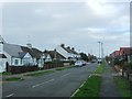
3

A299 Road, Thanet Way
Past Eddington junction with A291.
Image: © Oast House Archive
Taken: 23 Apr 2010
0.08 miles
4
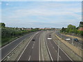
A299 Thanet Way towards Ramsgate
As seen from Image
This dual carriageway leads from the M2 (near Faversham) past Whitstable and Herne Bay and then it heads towards Ramsgate (past Manston Airport).
On the left is a on-ramp road from the roundabout junction on the A291 Canterbury Road. On the far right, is the off-ramp road towards the A291 to Herne Bay.
Image: © David Anstiss
Taken: 30 May 2011
0.11 miles
6
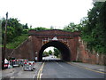
Railway Bridge over Canterbury Road, Herne Bay
Image: © Chris Whippet
Taken: 30 Jun 2014
0.13 miles
7
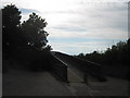
Footbridge over A299 Thanet Way
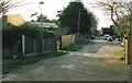
As seen from Pigeon Lane.
This bridge leads over the dual carriageway towards Bowes Lane, Eddington.
Image: © David Anstiss
Taken: 30 May 2011
0.14 miles
9
"Fifteen Acres" - A remnant of Parsonage Farm
View from the east end of Parsonage Road. This land was part of "Fifteen Acres", one of the few fields of Parsonage Farm that has survived the expansion of the new town of Herne Bay. On the 1840 Tythe Map Parsonage Farm consisted of a patchwork of fields spread between the old village of Herne Image almost down to the sea shore, then amounting to 165 acres. By the end of the 19th century the farm had been squeezed down to a few fields of cattle supplying 'The Creameries' in the town Image and by 1914 Parsonage Farm was virtually no more. See the Gallery at: http://www.geograph.org.uk/gallery/trail_of_a_kentish_farming_family_9094
(background family story http://books.google.com/books?id=hrpS_YQ9FoAC&printsec=frontcover&dq=On+Kentish+Chalk )
Image: © D Gore
Taken: Unknown
0.15 miles