IMAGES TAKEN NEAR TO
Reid Crescent, HERNE BAY, CT6 5FD
Introduction
This page details the photographs taken nearby to Reid Crescent, CT6 5FD by members of the Geograph project.
The Geograph project started in 2005 with the aim of publishing, organising and preserving representative images for every square kilometre of Great Britain, Ireland and the Isle of Man.

There are currently over 7.5m images from over14,400 individuals and you can help contribute to the project by visiting https://www.geograph.org.uk
Image Map
Images are licensed for reuse under creativecommons.org/licenses/by-sa/2.0
Notes
- Clicking on the map will re-center to the selected point.
- The higher the marker number, the further away the image location is from the centre of the postcode.
Image Listing (11 Images Found)
Images are licensed for reuse under creativecommons.org/licenses/by-sa/2.0
Image
Details
Distance
1
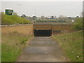
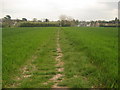
Subway under the A299
This tunnel is on a path from Mandarin Lane towards Lower Herne Road. The A299 heads left towards Margate and Ramsgate from Herne Bay and Whitstable.
Image: © David Anstiss
Taken: 25 Apr 2010
0.08 miles
2
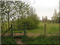
Kissing Gate near Herne Bay Golf Course
This gate (with unusual metal arch) is on a footpath from Lower Herne Road, which leads through the golf course towards Mandarin Lane.
Image: © David Anstiss
Taken: 25 Apr 2010
0.12 miles
3
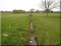
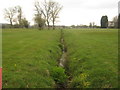
Plenty stream, looking downstream
As seen from Image This stream is in Herne Bay Golf Course. Leads from Round Wood to Herne Bay. In the background is a golfers bridge.
Image: © David Anstiss
Taken: 25 Apr 2010
0.17 miles
4
Footbridge on Plenty Brook
This footpath leads from Mandarin Lane, through Herne Bay Golf Course towards Lower Herne Road. It leads over a stream from Round Wood towards Herne Bay.
Image: © David Anstiss
Taken: 25 Apr 2010
0.19 miles
5
Plenty Brook , looking upstream
As seen from Image This stream in Herne Bay Golf Course. Leads from Round Wood to Herne Bay.
Image: © David Anstiss
Taken: 25 Apr 2010
0.21 miles
6
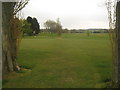
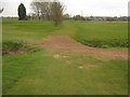
Footpath in Herne Bay Golf Course
A path leads from Mandarin Lane towards Lower Herne Road. It crosses several tees but is well used and easily followed.
Image: © David Anstiss
Taken: 25 Apr 2010
0.21 miles
7
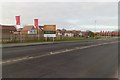
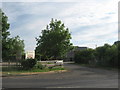
Housing Development off the Old Thanet Way
Image: © Mark Anderson
Taken: 2 Jan 2019
0.21 miles
8
Footpath to Lower Herne Road
This path leads from Mandarin Lane, Greenhill, through Herne Bay Golf Course, then under A299 dual carriageway towards Lower Herne.
Image: © David Anstiss
Taken: 25 Apr 2010
0.22 miles
9
The Clubhouse Restaurant, Herne Bay
As seen from the A2990 Thanet Way.
Restaurant and Club house of Herne Bay Golf Club.
Image: © David Anstiss
Taken: 30 May 2011
0.22 miles
10
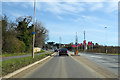
A2990 Thanet Way
The original A299, now bypassed by a newer alignment.
Image: © Robin Webster
Taken: 8 Feb 2018
0.24 miles