IMAGES TAKEN NEAR TO
Riverside, CANTERBURY, CT4 7NX
Introduction
This page details the photographs taken nearby to Riverside, CT4 7NX by members of the Geograph project.
The Geograph project started in 2005 with the aim of publishing, organising and preserving representative images for every square kilometre of Great Britain, Ireland and the Isle of Man.

There are currently over 7.5m images from over14,400 individuals and you can help contribute to the project by visiting https://www.geograph.org.uk
Image Map
Images are licensed for reuse under creativecommons.org/licenses/by-sa/2.0
Notes
- Clicking on the map will re-center to the selected point.
- The higher the marker number, the further away the image location is from the centre of the postcode.
Image Listing (67 Images Found)
Images are licensed for reuse under creativecommons.org/licenses/by-sa/2.0
Image
Details
Distance
1
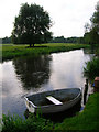
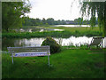
The Great Stour
The Great Stour is formed by the confluence of the Upper Great Stour and East Stour at Ashford before heading through Canterbury and becoming the River Stour at its former mouth near Preston on joining with the Little Stour. The boat belongs to one of the properties in Riverside a few yards to the right out of the picture.
Image: © Simon Carey
Taken: 24 Aug 2007
0.08 miles
5
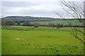
Flood Plain, River Great Stour
Beyond the river bank are the flooded fields of the Great Stour's flood plain. At times in the past they have been used as meadows dependent on the height of the river itself. The buildings beyond the flood plain belong to Deanery Farm and the furniture in front of the river to one of the properties behind the photographer.
Image: © Simon Carey
Taken: 24 Aug 2007
0.12 miles
6
Great Stour valley near Chartham
The red brick house in the centre of the photograph is Deanery Farm (also known as The Deanery), an eighteenth century building on the site of what had been a residence of the Deans of Canterbury until the seventeenth century.
Image: © David Kemp
Taken: 23 Apr 2009
0.12 miles
8
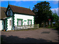
Riverside Gatehouse
Former level crossing keeper's cottage now turned into a desirable residence. Riverside is the name of the road the cottage is on and once crossed the line from Ashford but is now just for pedestrians.
Image: © Simon Carey
Taken: 24 Aug 2007
0.15 miles
9
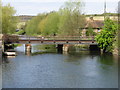
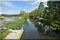
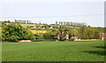
Railway line crossing the Great Stour
This is the London-Canterbury West-Ramsgate line.
Image: © Nick Smith
Taken: 26 Apr 2008
0.16 miles
10
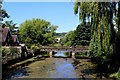
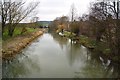
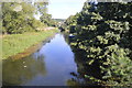
Great Stour at Chartham
Crystal clear chalk based river flowing through the village of Chartham - the low bridge carrying the Ashford/Canterbury West railway over the watercourse.
Image: © Chris Heaton
Taken: 9 Aug 2015
0.16 miles