IMAGES TAKEN NEAR TO
Faussett Hill, CANTERBURY, CT4 7AH
Introduction
This page details the photographs taken nearby to Faussett Hill, CT4 7AH by members of the Geograph project.
The Geograph project started in 2005 with the aim of publishing, organising and preserving representative images for every square kilometre of Great Britain, Ireland and the Isle of Man.

There are currently over 7.5m images from over14,400 individuals and you can help contribute to the project by visiting https://www.geograph.org.uk
Image Map
Images are licensed for reuse under creativecommons.org/licenses/by-sa/2.0
Notes
- Clicking on the map will re-center to the selected point.
- The higher the marker number, the further away the image location is from the centre of the postcode.
Image Listing (18 Images Found)
Images are licensed for reuse under creativecommons.org/licenses/by-sa/2.0
Image
Details
Distance
1
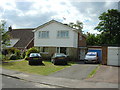
A house in White Hill Close
A short road of 16 houses in the tiny village of Lower Hardres.
Image: © Adrian Beaumont
Taken: 19 Jun 2004
0.09 miles
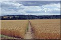
2
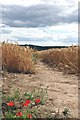
Poppies on the way to Lower Hardres
This path through the winter wheat is well defined
Image: © Glyn Baker
Taken: 25 Jul 2015
0.12 miles
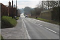
3
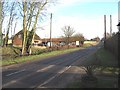
Junction of Bridge Road with Nackington Road
Image: © Nick Smith
Taken: 17 Feb 2007
0.12 miles
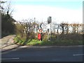
6
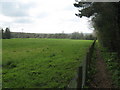
Footpath to Lower Hardres
A path from Bridge Road leads towards School Lane.
Image: © David Anstiss
Taken: 11 Apr 2010
0.14 miles
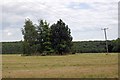
8
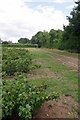
Blackcurrants Near Nacklington Rd
Looking towards the junction of Nacklington Rd and Image
Image: © Glyn Baker
Taken: 25 Jul 2015
0.15 miles
9
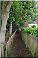
Footpath to Lower Hardres
The right of way passes between two gardens
Image: © Glyn Baker
Taken: 25 Jul 2015
0.16 miles