IMAGES TAKEN NEAR TO
North Elham, CANTERBURY, CT4 6UY
Introduction
This page details the photographs taken nearby to North Elham, CT4 6UY by members of the Geograph project.
The Geograph project started in 2005 with the aim of publishing, organising and preserving representative images for every square kilometre of Great Britain, Ireland and the Isle of Man.

There are currently over 7.5m images from over14,400 individuals and you can help contribute to the project by visiting https://www.geograph.org.uk
Image Map
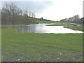
Images are licensed for reuse under creativecommons.org/licenses/by-sa/2.0
Notes
- Clicking on the map will re-center to the selected point.
- The higher the marker number, the further away the image location is from the centre of the postcode.
Image Listing (75 Images Found)
Images are licensed for reuse under creativecommons.org/licenses/by-sa/2.0
Image
Details
Distance
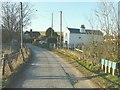
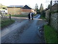
1
A lane in North Elham
Showing the location of an Image
Image: © John Baker
Taken: 25 Jun 2023
0.01 miles
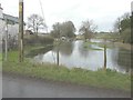
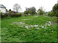
2
Flooding in the Elham Valley at North Elham
This view shows how the Image looked just after it had been excavated. The flooding was caused by the Nail Bourne bursting its banks.
Image: © John Baker
Taken: 10 Feb 2014
0.03 miles
3
Gate House, North Elham
Mrs Mutton was a former inhabitant of this building and was responsible for opening and closing the level crossing gates across this lane when the Elham Valley Railway was in existence. She would be alerted to an imminent train by bells from the signal box at Elham station. The house has been extended in recent years.
Image: © John Baker
Taken: 3 Feb 2012
0.03 miles
4
More extensive flooding beside the Gate House
In the course of a few weeks since I took Image, the flooding by the Nail Bourne has become more extensive. The Gate House was a former crossing keeper’s dwelling on the Elham Valley Railway.
Image: © John Baker
Taken: 10 Feb 2014
0.03 miles
5
Waterlogged meadow beside the Gate House
The extensive flooding seen in Image has disappeared but one would need waders to use the footpath that runs through this meadow.
Image: © John Baker
Taken: 27 Apr 2014
0.03 miles
6

Flooding beside the Gate House
This is the result of the Nail Bourne bursting its banks; it's several years since this has occurred. The Gate House was a former crossing keeper's dwelling on the Elham Valley Railway line.
Image: © John Baker
Taken: 19 Jan 2014
0.03 miles
7
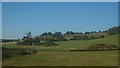
View of Hall Downs
As seen from a lane in North Elham.
Image: © David Anstiss
Taken: 18 Jul 2010
0.05 miles
8
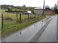
The Old Carthouse, North Elham
There are a couple of large piles of soil to the right of the house, where the ground seemed to have been excavated.
Image: © John Baker
Taken: 1 Mar 2016
0.05 miles
9
New extension to The Old Carthouse, North Elham
In November 2012, work had barely begun on the extension Image
Image: © John Baker
Taken: 19 Jan 2014
0.05 miles
10
The Nail Bourne in flood
There is a public footpath across the meadow, which follows the hedge towards the tree beside the river. The flooding was courtesy of Storm Dennis, which didn’t seem as severe as Storm Ciara in this part of the UK.
Image: © John Baker
Taken: 16 Feb 2020
0.05 miles