IMAGES TAKEN NEAR TO
Lickpot Hill, CANTERBURY, CT4 6TY
Introduction
This page details the photographs taken nearby to Lickpot Hill, CT4 6TY by members of the Geograph project.
The Geograph project started in 2005 with the aim of publishing, organising and preserving representative images for every square kilometre of Great Britain, Ireland and the Isle of Man.

There are currently over 7.5m images from over14,400 individuals and you can help contribute to the project by visiting https://www.geograph.org.uk
Image Map
Images are licensed for reuse under creativecommons.org/licenses/by-sa/2.0
Notes
- Clicking on the map will re-center to the selected point.
- The higher the marker number, the further away the image location is from the centre of the postcode.
Image Listing (23 Images Found)
Images are licensed for reuse under creativecommons.org/licenses/by-sa/2.0
Image
Details
Distance
3
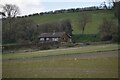
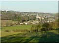
A distant view of Elham in 2001
As seen from an unnamed lane, with the spire of St Mary The Virgin church prominent above the trees.
Image: © John Baker
Taken: 22 May 2001
0.10 miles
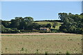
6
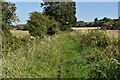
Kissing gate in hedgerow
As seen from the footpath above, with the village of Elham beyond.
Image: © John Baker
Taken: 17 Jan 2012
0.17 miles
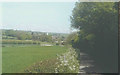
9
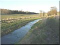
The Nail Bourne in flood
Seen from the Elham Valley Way, the level of the stream had receded but one can see where it had spilled over into the adjacent field.
Image: © John Baker
Taken: 23 Jan 2014
0.19 miles
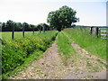
10
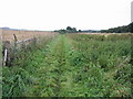
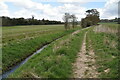
Looking SW along the Elham Valley Way
The Elham Valley Way is a 22.5 mile long path from Canterbury to Hythe, this section is from Elham to Lyminge, it follows the Nailbourne river through the valley at this point.
Image: © Nick Smith
Taken: 6 Sep 2008
0.19 miles