IMAGES TAKEN NEAR TO
Birch Court, CANTERBURY, CT4 6QW
Introduction
This page details the photographs taken nearby to Birch Court, CT4 6QW by members of the Geograph project.
The Geograph project started in 2005 with the aim of publishing, organising and preserving representative images for every square kilometre of Great Britain, Ireland and the Isle of Man.

There are currently over 7.5m images from over14,400 individuals and you can help contribute to the project by visiting https://www.geograph.org.uk
Image Map
Images are licensed for reuse under creativecommons.org/licenses/by-sa/2.0
Notes
- Clicking on the map will re-center to the selected point.
- The higher the marker number, the further away the image location is from the centre of the postcode.
Image Listing (107 Images Found)
Images are licensed for reuse under creativecommons.org/licenses/by-sa/2.0
Image
Details
Distance
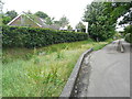
2
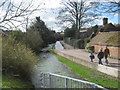
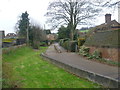
The Causeway, Derringstone
This narrow lane leads from Valley Road towards a crossroads in the village.
Beside is the River Nailbourne running through the village.
Image: © David Anstiss
Taken: 26 Mar 2010
0.04 miles
3
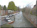
Floodwater flowing along The Causeway
The Nail Bourne usually flows in a channel beside a path, as seen from the other direction Image, but here sandbags have been positioned to that pedestrians can gain access to properties along South Barham Road and Railway Hill.
Image: © John Baker
Taken: 5 Feb 2014
0.05 miles
4
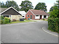
1, Farm House Close
Planning permission has been granted by Canterbury City Council under application number CA//17/00099 for a “proposed replacement outbuilding together with chimney”.
Number 1 is the bungalow built of red bricks and the outbuilding, under construction, is located just behind it; see also Image
Image: © John Baker
Taken: 1 Jul 2019
0.05 miles
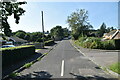
5
The course of the Nail Bourne in Barham
The Nail Bourne flows from Lyminge, through the Elham Valley until it becomes known as the Little Stour at Littlebourne. Whilst the stream often holds a plentiful supply of water from Lyminge to Elham throughout the year, it rarely holds any water from Elham to Bishopsbourne even in the winter months, as can be seen here. This is the view from Valley Road with The Causeway to the right.
The Little Stour then joins with the Great Stour at Plucks Gutter near West Stourmouth. A map of the Nail Bourne and more information about it can be seen at http://en.wikipedia.org/wiki/Little_Stour
Image: © Marathon
Taken: 7 Dec 2013
0.05 miles
6
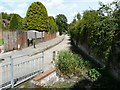
Looking northeast along The Causeway
Last May, a similar view showed Image Now there is no trace of the river.
Image: © John Baker
Taken: 3 Aug 2014
0.05 miles
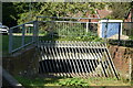
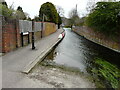
7
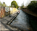
The Causeway
The channel, beside the path, helps to drain the Nail Bourne’s floodwater from Image
Image: © John Baker
Taken: 24 Feb 2021
0.06 miles
8
1, Farm House Close
Planning permission has been granted by Canterbury City Council under application number CA//17/00099 for a “proposed replacement outbuilding together with chimney”. This is a view of the house and the replacement outbuilding from The Causeway; see also Image
Image: © John Baker
Taken: 26 Jun 2019
0.06 miles
9
The Causeway
A view of Image, taken toward the end of February 2021, shows a greater volume of floodwater flowing along the channel.
Image: © John Baker
Taken: 1 Apr 2021
0.06 miles