IMAGES TAKEN NEAR TO
Out Elmstead Lane, CANTERBURY, CT4 6PH
Introduction
This page details the photographs taken nearby to Out Elmstead Lane, CT4 6PH by members of the Geograph project.
The Geograph project started in 2005 with the aim of publishing, organising and preserving representative images for every square kilometre of Great Britain, Ireland and the Isle of Man.

There are currently over 7.5m images from over14,400 individuals and you can help contribute to the project by visiting https://www.geograph.org.uk
Image Map
Images are licensed for reuse under creativecommons.org/licenses/by-sa/2.0
Notes
- Clicking on the map will re-center to the selected point.
- The higher the marker number, the further away the image location is from the centre of the postcode.
Image Listing (24 Images Found)
Images are licensed for reuse under creativecommons.org/licenses/by-sa/2.0
Image
Details
Distance
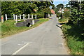
1
View towards Out Elmstead from Greenbanks
Image: © Nick Smith
Taken: 8 Oct 2009
0.03 miles
2
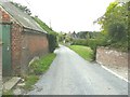
Out Elmstead Lane
The gap, beyond the building on the left, is the entrance to Out Elmstead Farm. The house, in the distance on the right, is known as Black Mill Cottage.
Image: © John Baker
Taken: 15 Sep 2013
0.04 miles
3
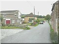
Out Elmstead Lane
The house nearest to the camera is called Penn; the house beyond it is semi-detached and known as numbers 1 & 2, Parrs Cottage.
Image: © John Baker
Taken: 15 Sep 2013
0.04 miles

5
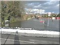
Out Elmstead Lane
A line of sandbags has been placed across the entrance to the lane to prevent the flooding of Valley Road by the Nail Bourne, which has burst its banks. A ford is marked on the map and its location is seen here by the white railing on the left.
Image: © John Baker
Taken: 13 Feb 2014
0.07 miles
6
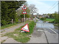
Out Elmstead Lane
This was a view of Image when the Nail Bourne had burst its banks, although this view shows that it might be possible to drive a car through the ford.
Image: © John Baker
Taken: 16 Apr 2020
0.08 miles
7
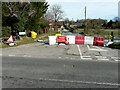
Out Elmstead Lane
A barrier has been erected to prevent the floodwater of the Nail Bourne from infiltrating Valley Road. This view of Image was taken in April 2020. I have never known the river to flood in consecutive years, in the twenty years I have lived in the area.
Image: © John Baker
Taken: 24 Feb 2021
0.11 miles
8
The ford at Out Elmstead Lane
The Nail Bourne was still flowing strongly across the lane but it was possible to drive a car through the ford unlike Image, when the road was closed to all traffic!
Image: © John Baker
Taken: 4 May 2014
0.11 miles
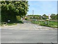
9
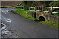
Out Elmstead Ford
This ford on the Nailbourne is found on Out Elmstead Lane.
Image: © John Walton
Taken: 7 Nov 2013
0.11 miles