IMAGES TAKEN NEAR TO
The Street, CANTERBURY, CT4 6JQ
Introduction
This page details the photographs taken nearby to The Street, CT4 6JQ by members of the Geograph project.
The Geograph project started in 2005 with the aim of publishing, organising and preserving representative images for every square kilometre of Great Britain, Ireland and the Isle of Man.

There are currently over 7.5m images from over14,400 individuals and you can help contribute to the project by visiting https://www.geograph.org.uk
Image Map
Images are licensed for reuse under creativecommons.org/licenses/by-sa/2.0
Notes
- Clicking on the map will re-center to the selected point.
- The higher the marker number, the further away the image location is from the centre of the postcode.
Image Listing (25 Images Found)
Images are licensed for reuse under creativecommons.org/licenses/by-sa/2.0
Image
Details
Distance
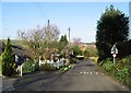
1
82, The Street
Planning permission has been approved by Canterbury City Council under application number CA/ 22/00995 for a “two-storey and part single-storey rear and side extension following demolition of the existing side extension and detached garage”. |
The extension will be built where the car is parked.
Image: © John Baker
Taken: 30 Oct 2022
0.04 miles
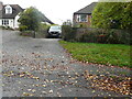
4
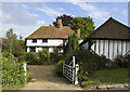
Whitelocks Farm, Kingston, Kent
The Farmhouse on The Street is a listed building
Image: © Paul Harrop
Taken: 14 Aug 2010
0.07 miles
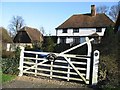
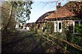
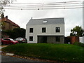
6
Hoods Place, 64, The Street
Planning permission has been granted by Canterbury City Council under application number CA/20/00729 for a “proposed three-storey detached dwelling with associated landscaping, parking and refuse store”.
After its construction, the dwelling was named Image; the wall and gates had been removed during the development.
The house, to which this development refers, is located out of shot, to the right.
Image: © John Baker
Taken: 5 Jul 2020
0.09 miles
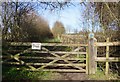
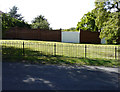
8
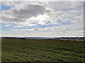
Kingston village in Kent from the North Downs Way
The view south-west from Barham Downs on the North Downs Way, looking towards the village of Kingston, Kent.
Image: © Phil Brandon Hunter
Taken: 2 Feb 2022
0.10 miles
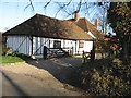
9
Highfield House, The Street
This was the lawn of Image on which this house was built.
Image: © John Baker
Taken: 30 Oct 2022
0.11 miles