IMAGES TAKEN NEAR TO
Mill Lane, Dover Road, CANTERBURY, CT4 6HH
Introduction
This page details the photographs taken nearby to Mill Lane, Dover Road, CT4 6HH by members of the Geograph project.
The Geograph project started in 2005 with the aim of publishing, organising and preserving representative images for every square kilometre of Great Britain, Ireland and the Isle of Man.

There are currently over 7.5m images from over14,400 individuals and you can help contribute to the project by visiting https://www.geograph.org.uk
Image Map
Images are licensed for reuse under creativecommons.org/licenses/by-sa/2.0
Notes
- Clicking on the map will re-center to the selected point.
- The higher the marker number, the further away the image location is from the centre of the postcode.
Image Listing (23 Images Found)
Images are licensed for reuse under creativecommons.org/licenses/by-sa/2.0
Image
Details
Distance
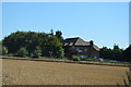
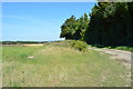
4
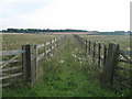
North Downs Way near Upper Digges Farm
The long distance path leads from the farm on a bridleway through the Barham Downs towards Patrixbourne.
Image: © David Anstiss
Taken: 5 Sep 2010
0.04 miles
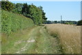
8
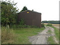
Barn and North Downs Way near Upper Digges Farm
The long distance path leads along a bridleway from the B2046 Adisham Road, then it turns left to head to a bridleway through the Barham Downs.
Note, the path does not follows exactly like the maps show the path.
Image: © David Anstiss
Taken: 5 Sep 2010
0.11 miles
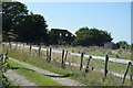
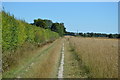
9
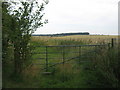
Bridle gate near Upper Digges Farm
The North Downs Way (long distance path) heads from the Barham Downs, past the farm and then through this gate to head on another bridleway towards Aylesham Cemetery on the Adisham Road.
Ileden Wood is in the background
Image: © David Anstiss
Taken: 5 Sep 2010
0.11 miles
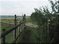
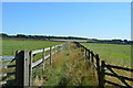
10
Unused bridleway to Westmore House
This track between horse paddocks leads from Upper Digges Farm on the North Downs Way (long distance path), it heads towards the B2046 Adisham Road near the house.
Image: © David Anstiss
Taken: 5 Sep 2010
0.12 miles