IMAGES TAKEN NEAR TO
Sandhills, CANTERBURY, CT3 2NG
Introduction
This page details the photographs taken nearby to Sandhills, CT3 2NG by members of the Geograph project.
The Geograph project started in 2005 with the aim of publishing, organising and preserving representative images for every square kilometre of Great Britain, Ireland and the Isle of Man.

There are currently over 7.5m images from over14,400 individuals and you can help contribute to the project by visiting https://www.geograph.org.uk
Image Map
Images are licensed for reuse under creativecommons.org/licenses/by-sa/2.0
Notes
- Clicking on the map will re-center to the selected point.
- The higher the marker number, the further away the image location is from the centre of the postcode.
Image Listing (9 Images Found)
Images are licensed for reuse under creativecommons.org/licenses/by-sa/2.0
Image
Details
Distance
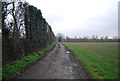
1
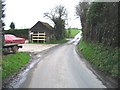
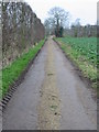
Lane leading to Upper Goldstone, Sandhill Farm building on left.
Image: © Nick Smith
Taken: 9 Jan 2007
0.11 miles
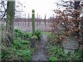
2
The Stour Valley Walk crosses the lane near Standhill Farm
The long distance path leads from Cooper Street Drove, past Fleet Farm, through a field to the lane near Sandhills and then through an large orchard towards a lane to Lower Goldstone.
Image: © David Anstiss
Taken: 16 Jan 2011
0.16 miles
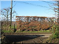
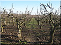
3
Stour Valley footpath crossing road and entering an orchard (looking NW).
Image: © Nick Smith
Taken: 9 Jan 2007
0.16 miles
4
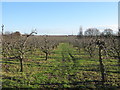
Stour Valley Walk to a lane near Sandhills Farm
The long distance path leads from the lane to Lower Goldstone, through a large orchard, towards a leading from Sandhills Farm towards Richborough.
Image: © David Anstiss
Taken: 16 Jan 2011
0.17 miles
5
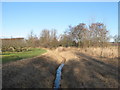
Drain in an orchard near Lower Goldstone
This drain leads through the orchard, from Standhill Farm towards the Ash Levels.
Image: © David Anstiss
Taken: 16 Jan 2011
0.18 miles
6
Stour Valley Walk footpath to Richborough Road
The long distance path leads from the lane near Lower Goldstone, towards the road near Sandhills Farm.
Image: © David Anstiss
Taken: 16 Jan 2011
0.19 miles
7
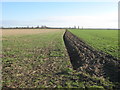
Stour Valley Walk to Cooper Street Drove
The long distance path leads from the lane near Standhills Farm, via a field edge path towards the lane near Fleet Farm.
This path used to travel through another orchard, this section though has been dug up and become two arable fields.
Image: © David Anstiss
Taken: 16 Jan 2011
0.20 miles
9
View along footpath and private road to Lower Goldstone
Taken from near the junction of the track and Richborough Road at Sparrow Castle.
Image: © Nick Smith
Taken: 1 Jan 2008
0.25 miles