IMAGES TAKEN NEAR TO
Ash Bypass, CANTERBURY, CT3 2EQ
Introduction
This page details the photographs taken nearby to Ash Bypass, CT3 2EQ by members of the Geograph project.
The Geograph project started in 2005 with the aim of publishing, organising and preserving representative images for every square kilometre of Great Britain, Ireland and the Isle of Man.

There are currently over 7.5m images from over14,400 individuals and you can help contribute to the project by visiting https://www.geograph.org.uk
Image Map
Images are licensed for reuse under creativecommons.org/licenses/by-sa/2.0
Notes
- Clicking on the map will re-center to the selected point.
- The higher the marker number, the further away the image location is from the centre of the postcode.
Image Listing (20 Images Found)
Images are licensed for reuse under creativecommons.org/licenses/by-sa/2.0
Image
Details
Distance
1
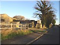
Farm buildings at Chequer Court, Knell Lane
Image: © Nick Smith
Taken: 19 Jan 2007
0.01 miles
2
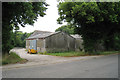
Chequer Court Farm
Atcost type barns off Knell Lane.
Image: © Oast House Archive
Taken: 20 Jul 2010
0.03 miles
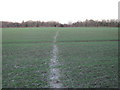
3
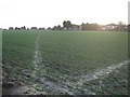
Footpath junction near the A257 Pedding Road
A path leads straight on through the field towards Chequer Lane. Another path leads right through the field towards Molland Lea.
Image: © David Anstiss
Taken: 16 Jan 2011
0.11 miles
4
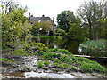
The moat at Chequer Court
It is a grade II listed house, which dates from the 16th century. It was refaced in the 17th century and extended in the 19th and late 20th centuries http://www.britishlistedbuildings.co.uk/101070215-chequer-court-ash#.WQYxMP6GPcc I had chosen to walk along the edge of a field (and therefore was rewarded with this picturesque view), because the footpath had not been marked out across ridges, created for sowing potatoes, and this would have made the going hard work.
Image: © John Baker
Taken: 16 Apr 2017
0.11 miles
5
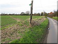
Knell Lane and footpath to Little Knell Farm
Image: © Nick Smith
Taken: 20 Feb 2009
0.13 miles
6
Molland Lane bridleway to Guilton
This section of the lane from Paramour Street to Ash, has been turned into a lane, due to the A257 Pedding Hill / Sandwich Road cutting the lane in two. The lane still leads to Paramour Street in the Ash Levels. But this section near Ash is now a bridleway track.
See also Image
Image: © David Anstiss
Taken: 16 Jan 2011
0.13 miles
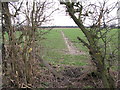
7
Footpath to the A257 Pedding Hill
This field path leads from Molland Lea, towards the main Canterbury/Sandwich road cutting around Ash.
Image: © David Anstiss
Taken: 16 Jan 2011
0.14 miles
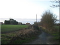
10
The end of Molland Lane, Ash
Molland Lane originally continued along this route but a new road cuts through and the lane was closed to through traffic, now only a bridleway continues.
Image: © Nick Smith
Taken: 19 Jan 2007
0.19 miles