IMAGES TAKEN NEAR TO
Lion Walk, The Street, CANTERBURY, CT3 2AW
Introduction
This page details the photographs taken nearby to Lion Walk, The Street, CT3 2AW by members of the Geograph project.
The Geograph project started in 2005 with the aim of publishing, organising and preserving representative images for every square kilometre of Great Britain, Ireland and the Isle of Man.

There are currently over 7.5m images from over14,400 individuals and you can help contribute to the project by visiting https://www.geograph.org.uk
Image Map
Images are licensed for reuse under creativecommons.org/licenses/by-sa/2.0
Notes
- Clicking on the map will re-center to the selected point.
- The higher the marker number, the further away the image location is from the centre of the postcode.
Image Listing (94 Images Found)
Images are licensed for reuse under creativecommons.org/licenses/by-sa/2.0
Image
Details
Distance
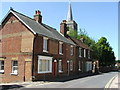
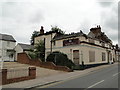
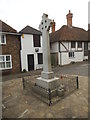
2
The Street, Ash from St Nicholas' churchyard
On the left is the former Lagaan Restaurant (number 60) that was gutted by fire on 17 January 2009 as reported in these links http://www.thisiskent.co.uk/Investigation-Indian-restaurant/story-12000873-detail/story.html and http://news.bbc.co.uk/1/hi/england/kent/7835051.stm It is now to be rebuilt. Planning permission has been granted by Dover District Council under application number DOV/12/00678 for “change of use, conversion and rebuilding of existing building to form two semi-detached dwellings and creation of a detached car port”.
Image: © John Baker
Taken: 30 Dec 2012
0.02 miles
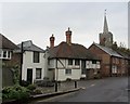
3
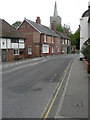
The Street
The view shows a ghost sign on the side wall of number 67 (whose post code is CT3 2 EN). The words on the sign are indecipherable but I was able to compare the address from an old street directory (published by Yellow Pages) with one on the same page, which showed that this was once Church Gates Bakery.
Here is a description of the premises (although the name of the road is incorrect). Church Gates Bakery: this bakery on Ash High Street was owned for years by the Solly/Solley/Coleman family. It was then leased to Alexander Clark from 1922 to 1936. After that it was sold to a Mrs Hollaway https://www.curiousfox.com/vill100/Kent11296_1.html
Image: © John Baker
Taken: 14 Aug 2020
0.02 miles
4
Looking east along The Street
From the churchyard of St Nicholas towards the white-painted building which has been named Ashton House (number 60). It was built on the site of the Lagaan restaurant seen in Image
Image: © John Baker
Taken: 22 Feb 2015
0.02 miles
5
Burnt out Indian restaurant, Ash
An interesting story here, I bet
Image: © Tim Evans
Taken: 21 Jul 2011
0.02 miles
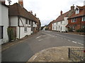
6
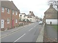
In Ash
The Street - which is the main thoroughfare of this community, as seen near the church.
Image: © Chris Heaton
Taken: 19 Oct 2013
0.02 miles
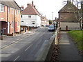
7
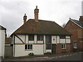
Cobwebs, Ash
An historic building of Kent on The Street, opposite Queens Road.
Is Grade II Listed but known as 75, The Lion Cottage.
See http://www.britishlistedbuildings.co.uk/en-178119-the-lion-cottage-75-ash for more details about the building.
Image: © David Anstiss
Taken: 13 Feb 2011
0.03 miles
8
Moat Lane at the junction of The Street, Ash
Image: © David Howard
Taken: 22 Jun 2017
0.03 miles
10
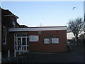
Ash Library
In an extension built on to Image, on Queens Road.
In the background is a free car park for the Hall, library and village.
Image: © David Anstiss
Taken: 16 Jan 2011
0.04 miles