IMAGES TAKEN NEAR TO
CT2 8LD
Introduction
This page details the photographs taken nearby to CT2 8LD by members of the Geograph project.
The Geograph project started in 2005 with the aim of publishing, organising and preserving representative images for every square kilometre of Great Britain, Ireland and the Isle of Man.

There are currently over 7.5m images from over14,400 individuals and you can help contribute to the project by visiting https://www.geograph.org.uk
Image Map
Images are licensed for reuse under creativecommons.org/licenses/by-sa/2.0
Notes
- Clicking on the map will re-center to the selected point.
- The higher the marker number, the further away the image location is from the centre of the postcode.
Image Listing (161 Images Found)
Images are licensed for reuse under creativecommons.org/licenses/by-sa/2.0
Image
Details
Distance
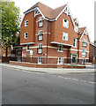
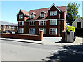
1
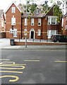
London Court, London Road
This was the Image in April 2018.
Image: © John Baker
Taken: 4 Aug 2019
0.02 miles
2
60A, London Road
Planning permission has been granted by Canterbury City Council under application number CA//16/02886 for a “variation of condition 02 (approved drawings) of appeal reference APP/J2210/W/15/3140462, (planning application CA/15/01179/FUL) for demolition of house and construction of new building incorporating 10 flats, to allow amendments to internal layout, addition of dormer to front and roof-lights to side elevation”.
Image: © John Baker
Taken: 4 Feb 2018
0.03 miles
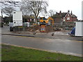
3
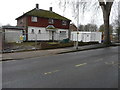
Building site, London Road
Planning permission has been granted by Canterbury City Council under application number CA//16/02886 for a “variation of condition 02 (approved drawings) of appeal reference APP/J2210/W/15/3140462, (planning application CA/15/01179/FUL) for demolition of house and construction of new building incorporating 10 flats, to allow amendments to internal layout, addition of dormer to front and roof-lights to side elevation”.
This image shows the house numbered Image that stood on the site and before it was demolished. Image now stands here.
Image: © John Baker
Taken: 29 Apr 2018
0.03 miles
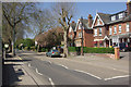
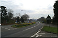
4
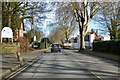
London Road, Canterbury
A somewhat surprising indirect route for what was presumably once the main way into Canterbury from London.
Image: © Robin Webster
Taken: 8 Feb 2018
0.04 miles
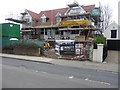
5
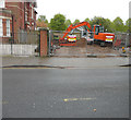
Building site, 43, Queens Avenue
Planning permission has been granted by Canterbury City Council under application number CA//16/02781 for the “proposed erection of three-storey building containing seven apartments following demolition of existing building”.
Just beyond the site is Image, while Image now stands here.
Image: © John Baker
Taken: 4 Feb 2018
0.04 miles
6
Alexandra House, 43, Queens Avenue
This was the Image in February 2018.
Image: © John Baker
Taken: 4 Aug 2019
0.04 miles
7
London Road, Canterbury
Looking west from the junction with Princes Way.
Image: © Stephen McKay
Taken: 6 May 2013
0.05 miles
8
Erection of apartments, 65-65A London Road
Planning permission has been granted by Canterbury City Council under application number CA//12/00720 for the “demolition of one pair of semi-detached dwellings and erection of 14 apartments”. The site is also on the corner of Princes Way. This view shows the former entrance. This building has since been named Image
Image: © John Baker
Taken: 27 Dec 2015
0.06 miles
9
Thomas Court, London Road
The front entrance to the apartments is now in Princes Way. This view shows the Image
Image: © John Baker
Taken: 21 May 2017
0.06 miles
10
The pilgrims' view of Canterbury Cathedral
The Pilgrim's Way comes down to meet the old A2 and its replacement A2050 below Harbledown hill, and the Cathedral lies straight ahead.
Image: © David Long
Taken: 21 Apr 2006
0.06 miles