IMAGES TAKEN NEAR TO
Pine Tree Avenue, CANTERBURY, CT2 7TA
Introduction
This page details the photographs taken nearby to Pine Tree Avenue, CT2 7TA by members of the Geograph project.
The Geograph project started in 2005 with the aim of publishing, organising and preserving representative images for every square kilometre of Great Britain, Ireland and the Isle of Man.

There are currently over 7.5m images from over14,400 individuals and you can help contribute to the project by visiting https://www.geograph.org.uk
Image Map
Images are licensed for reuse under creativecommons.org/licenses/by-sa/2.0
Notes
- Clicking on the map will re-center to the selected point.
- The higher the marker number, the further away the image location is from the centre of the postcode.
Image Listing (249 Images Found)
Images are licensed for reuse under creativecommons.org/licenses/by-sa/2.0
Image
Details
Distance
1
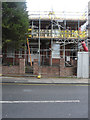
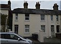
38, Whitstable Road
Planning permission has been granted by Canterbury City Council under application number CA//14/02295 for the “extension of existing dwelling and erection of four-unit apartment block”.
This image shows Image before any work started. It is referred to as the ‘existing dwelling’ in the planning application.
Image: © John Baker
Taken: 4 Feb 2018
0.07 miles
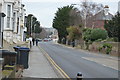
2
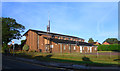
Church of Jesus Christ of Latter Day Saints
Canterbury's Mormon church, on Forty Acres Road.
Image: © Des Blenkinsopp
Taken: 29 Aug 2011
0.07 miles
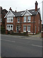
3

38, Whitstable Road
Planning permission has been granted by Canterbury City Council under application number CA//14/02295 for the “extension of existing dwelling and erection of four-unit apartment block”.
Image: © John Baker
Taken: 19 Feb 2017
0.08 miles
4
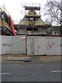
Apartments under construction at 38, Whitstable Road
Planning permission has been granted by Canterbury City Council under application number CA//14/02295 for the “extension of existing dwelling and erection of four-unit apartment block”.
This image shows Image before the work started. It is referred to as the ‘existing dwelling’ in the planning application.
Image: © John Baker
Taken: 4 Feb 2018
0.08 miles

7
![Canterbury houses [8]](https://s3.geograph.org.uk/geophotos/07/08/16/7081619_e660a0a6_120x120.jpg)
Canterbury houses [8]
Holly Tree Cottage, number 34 Whitstable Road, is a detached house with two parallel ranges. Built in the late 18th or early 19th century of stuccoed brick under a tile roof. Listed, grade II, with details at: https://historicengland.org.uk/listing/the-list/list-entry/1242880
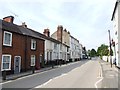
Canterbury is a small historic city on the River Stour in Kent, some 54 miles southeast of London. Occupied since prehistoric times, it became an important Roman city. In 672, the see of Canterbury gained authority over the entire English Church. After the murder of Archbishop Thomas Becket at the cathedral in 1170, pilgrims from all parts of Christendom came to visit his shrine until the Dissolution. Today, Canterbury is a popular tourist destination and one of the most-visited cities in the United Kingdom. The city has a substantial student population, with four university campuses.
Image: © Michael Dibb
Taken: 5 Sep 2021
0.09 miles
9
63 Whitstable Road
Planning permission has been granted by Canterbury City Council under application number CA//14/01196 for a “change of use from residential care home (C2) to guest house (C1). Demolition of single-storey extension and erection of two-storey extension. Addition of roof-light to front roof slope and railings and advertising signboard to front of site”.
Image: © John Baker
Taken: 27 Dec 2015
0.09 miles